Radroute in North Adelaide, South Australia, Australien
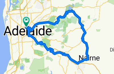
Day 6_T/T_Doughnuts in Hahndorf Ride
1
Route in der Bikemap App öffnen

Diese Route in Bikemap Web öffnen
106
km
Distanz
Distanz
1157
m
Aufstieg
Aufstieg
1157
m
Abstieg
Abstieg
-:--
h
Dauer
Dauer
--
km/h
ø-Tempo
ø-Tempo
---
m
Max. Höhe
Max. Höhe


