
Cycling in Unterpleichfeld
Discover a map of 64 cycling routes and bike trails near Unterpleichfeld, created by our community.
Region portrait
Get to know Unterpleichfeld
Find the right bike route for you through Unterpleichfeld, where we've got 64 cycle routes to explore. Most people get on their bikes to ride here in the month of April.
3,471 km
Tracked distance
64
Cycle routes
2,718
Population
Community
Most active users in Unterpleichfeld


From our community
The best bike routes in and around Unterpleichfeld

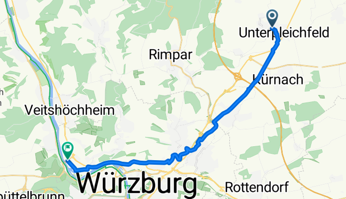
Unterpleichfeld-Volkach
Cycling route in Unterpleichfeld, Bavaria, Germany
Uplfd-Seligenstadt-Neusetz-Köhler-Eschendorf-Astheim-Volkach-Fahr-Stammheim-(Fähre)-Wipfeld-Schwanfeld-Bergtheim-Uplfd.
- 46.3 km
- Distance
- 247 m
- Ascent
- 247 m
- Descent

Unterpleichfeld - Grammschatzer Wald
Cycling route in Unterpleichfeld, Bavaria, Germany
- 51.8 km
- Distance
- 416 m
- Ascent
- 420 m
- Descent
Unterpleichfeld-Zell-Winterroute
Cycling route in Unterpleichfeld, Bavaria, Germany
- 17.5 km
- Distance
- 128 m
- Ascent
- 230 m
- Descent

Unterpleichfeld - Mühlhausen - Maidbronn - Rimpar - Oberdürrbach - Unterdürrbach - Zell
Cycling route in Unterpleichfeld, Bavaria, Germany
Strecke mit Radwegen bzw. wenig befahrenen Straßen, dafür einigen Hügeln
- 20.6 km
- Distance
- 207 m
- Ascent
- 310 m
- Descent
Discover more routes
 Unterpleichfeld - Ochsenfurt - Creglingen - Crailsheim - Ellwangen
- Distance
- 131.9 km
- Ascent
- 563 m
- Descent
- 406 m
- Location
- Unterpleichfeld, Bavaria, Germany
 BY-Radltour 2015 - 01 - Unterpleichfeld - Postbauer-Heng (über Kitzingen - Iphofen - Markt Bibart - Scheinfeld - Diespeck - Hagenbüchach - Fürth - Nürnberg - We
- Distance
- 148.6 km
- Ascent
- 550 m
- Descent
- 367 m
- Location
- Unterpleichfeld, Bavaria, Germany
 Unterpleichfeld - Zell
- Distance
- 18.1 km
- Ascent
- 108 m
- Descent
- 214 m
- Location
- Unterpleichfeld, Bavaria, Germany
 Trainingsrunde Fahrradwege
- Distance
- 57 km
- Ascent
- 211 m
- Descent
- 211 m
- Location
- Unterpleichfeld, Bavaria, Germany
 Gramschatz2
- Distance
- 35.2 km
- Ascent
- 446 m
- Descent
- 447 m
- Location
- Unterpleichfeld, Bavaria, Germany
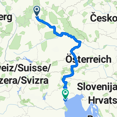 Unterpleichfeld - Venedig
- Distance
- 1,017.2 km
- Ascent
- 2,995 m
- Descent
- 3,262 m
- Location
- Unterpleichfeld, Bavaria, Germany
 Unterpleichfeld-Kreuzberg
- Distance
- 93.1 km
- Ascent
- 1,332 m
- Descent
- 688 m
- Location
- Unterpleichfeld, Bavaria, Germany
 Unterpleichfeld-KlosterKreuzberg
- Distance
- 79.5 km
- Ascent
- 1,198 m
- Descent
- 594 m
- Location
- Unterpleichfeld, Bavaria, Germany