
Cycling in Thalheim
Discover a map of 45 cycling routes and bike trails near Thalheim, created by our community.
Region portrait
Get to know Thalheim
Find the right bike route for you through Thalheim, where we've got 45 cycle routes to explore.
3,249 km
Tracked distance
45
Cycle routes
7,583
Population


From our community
The best bike routes in and around Thalheim


Berghausweg, Thalheim/Erzgeb. nach Hauptstraße 38, Pöhl
Cycling route in Thalheim, Saxony, Germany
- 82.2 km
- Distance
- 1,003 m
- Ascent
- 1,088 m
- Descent


Tabakstanne Talsperre kurz
Cycling route in Thalheim, Saxony, Germany
- 13.2 km
- Distance
- 262 m
- Ascent
- 264 m
- Descent
Discover more routes
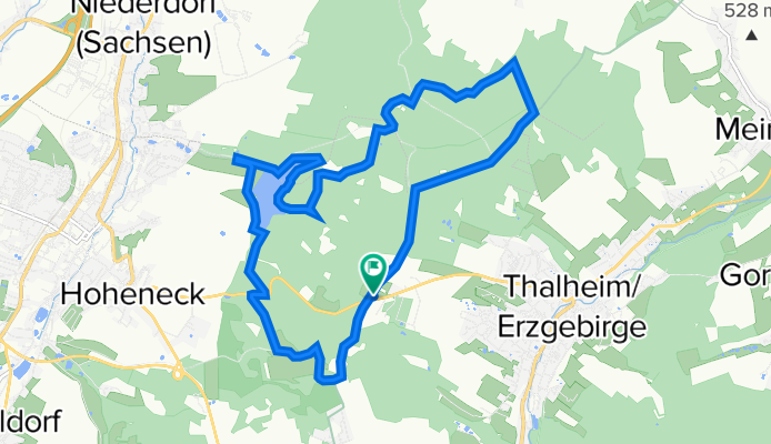
 Rund um Thalheim
- Distance
- 15.2 km
- Ascent
- 308 m
- Descent
- 309 m
- Location
- Thalheim, Saxony, Germany
 Thalheim F 6 - Eibenberger Allee - und zurück
- Distance
- 23.4 km
- Ascent
- 251 m
- Descent
- 252 m
- Location
- Thalheim, Saxony, Germany
 Jahnsdorfer Straße, Thalheim/Erzgeb. nach Jahnsdorfer Straße, Thalheim/Erzgeb.
- Distance
- 3.7 km
- Ascent
- 32 m
- Descent
- 65 m
- Location
- Thalheim, Saxony, Germany
 Untere Hauptstraße 26A, Thalheim/Erzgeb. nach Untere Hauptstraße 26A, Thalheim/Erzgeb.
- Distance
- 29.9 km
- Ascent
- 524 m
- Descent
- 521 m
- Location
- Thalheim, Saxony, Germany
 Thalheim_Chemnitz
- Distance
- 21 km
- Ascent
- 252 m
- Descent
- 380 m
- Location
- Thalheim, Saxony, Germany
 bikeroute to tirana
- Distance
- 1,963.8 km
- Ascent
- 5,127 m
- Descent
- 5,480 m
- Location
- Thalheim, Saxony, Germany
 Uferstraße 11, Thalheim/Erzgeb. nach Uferstraße 11, Thalheim/Erzgeb.
- Distance
- 21.8 km
- Ascent
- 435 m
- Descent
- 481 m
- Location
- Thalheim, Saxony, Germany
 Windmühlenweg 6, Zwönitz nach Sörnewitzer Straße 48A, Weinböhla
- Distance
- 96.1 km
- Ascent
- 1,012 m
- Descent
- 1,431 m
- Location
- Thalheim, Saxony, Germany