
Cycling in Brunnthal
Discover a map of 202 cycling routes and bike trails near Brunnthal, created by our community.
Region portrait
Get to know Brunnthal
Find the right bike route for you through Brunnthal, where we've got 202 cycle routes to explore. Most people get on their bikes to ride here in the months of May and July.
13,267 km
Tracked distance
202
Cycle routes
4,628
Population


From our community
The best bike routes in and around Brunnthal

Kichstockach-Otterfing-Kreuzsraße-Valley-Holzkirchen-Sauerlach
Cycling route in Brunnthal, Bavaria, Germany
ca. 62km; kompltette Streckerennradtauglich; Einkehrmöglichkeit Bartewirt (Kreuzstraße) oder Valley Arco Brauereibiergarten
- 58.8 km
- Distance
- 211 m
- Ascent
- 211 m
- Descent
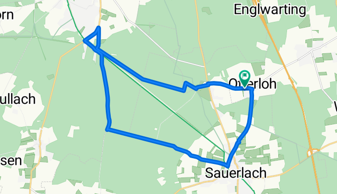
Otterloh - Deisenhofener Forst - Sauerlach
Cycling route in Brunnthal, Bavaria, Germany
Schöne Strecke durch den Wald, wenig auf befahrenen Strassen und wenn, dann mit Radwegen. Ideal für Kinder unter 10 :)
- 16.4 km
- Distance
- 118 m
- Ascent
- 120 m
- Descent

Walchstatt - Ascholding
Cycling route in Brunnthal, Bavaria, Germany
Walchstatt
K'pullach
Hornstein
Ascholding
Harmating
Ried
Jasberg
Hofolding
Walchstatt
05.03.2011
20.03.2011
- 82.5 km
- Distance
- 563 m
- Ascent
- 563 m
- Descent

Hofoldinger TT-Runde
Cycling route in Brunnthal, Bavaria, Germany
Rundstrecke für zügiges Fahren.
- 23.9 km
- Distance
- 99 m
- Ascent
- 96 m
- Descent
Discover more routes
 Route in Brunnthal
- Distance
- 36 km
- Ascent
- 170 m
- Descent
- 170 m
- Location
- Brunnthal, Bavaria, Germany
 Hofolding-Sauerlach-Grosseichenhausen-Arget-Otterloh-Hofolding
- Distance
- 33.5 km
- Ascent
- 213 m
- Descent
- 212 m
- Location
- Brunnthal, Bavaria, Germany
 Brunnthal - Deininger Weiher - Brunnthal
- Distance
- 45.8 km
- Ascent
- 405 m
- Descent
- 378 m
- Location
- Brunnthal, Bavaria, Germany
 Brunnthal - Egmating - Altenburg - Zorneding - Brunnthal
- Distance
- 47.8 km
- Ascent
- 346 m
- Descent
- 359 m
- Location
- Brunnthal, Bavaria, Germany
 Deininger Weiher
- Distance
- 38.2 km
- Ascent
- 180 m
- Descent
- 180 m
- Location
- Brunnthal, Bavaria, Germany
 Taubenbergrunde
- Distance
- 66.8 km
- Ascent
- 664 m
- Descent
- 642 m
- Location
- Brunnthal, Bavaria, Germany
 Walchstatt-Valepp
- Distance
- 119.5 km
- Ascent
- 867 m
- Descent
- 867 m
- Location
- Brunnthal, Bavaria, Germany
 Rund um Aying
- Distance
- 39.4 km
- Ascent
- 195 m
- Descent
- 195 m
- Location
- Brunnthal, Bavaria, Germany