
Route template
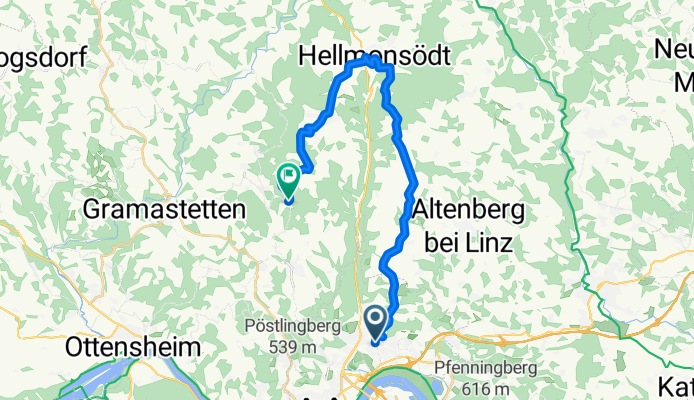
Linz to Eidenberg

- 1 h 36 min
- Duration
- 23.8 km
- Distance
- 661 m
- Ascent
- 253 m
- Descent
- 14.8 km/h
- Avg. speed
- 685 m
- Max. altitude
Get ready for a delightful cycling journey from the vibrant city of Linz to the charming town of Eidenberg! This route covers about 24 kilometers, making it a perfect ride to soak in the picturesque Austrian countryside.
Starting in Linz, known for its blend of contemporary art scenes and rich history, you'll embark on a mostly quiet road journey. You'll definitely appreciate those stretches along dedicated cycleways where you can admire the serene surroundings without much traffic to worry about.
As you pedal your way up, gaining over 660 meters in elevation, the views only get better. Your highest point will be around 685 meters above sea level, so be ready for some sweeping panoramic views—it’s well worth the effort!
The surface varies, with significant portions being asphalt, keeping your ride smooth and pleasant. Once you roll into Eidenberg, take a moment to enjoy this peaceful village—an idyllic spot to unwind after such a rewarding ride. Whether you're sharing a coffee with locals or exploring its quaint streets, Eidenberg is sure to leave you charmed. Happy cycling!
Community
Top users in this region


From our community
The best bike routes from Linz to Eidenberg

Dießenleitental-Gis
Cycling route in Linz, Upper Austria, Austria
- 10.2 km
- Distance
- 663 m
- Ascent
- 46 m
- Descent


160er-Hellmonsödt-Kirchschlag-Gis
Cycling route in Linz, Upper Austria, Austria
- 23.2 km
- Distance
- 958 m
- Ascent
- 333 m
- Descent

Auberg - Gis
Cycling route in Linz, Upper Austria, Austria
- 11.6 km
- Distance
- 757 m
- Ascent
- 115 m
- Descent

GH Lindbauer_Höllmühlstr_Gis
Cycling route in Linz, Upper Austria, Austria
- 10.6 km
- Distance
- 646 m
- Ascent
- 19 m
- Descent

GIS über Pöstlingberg
Cycling route in Linz, Upper Austria, Austria
- 18.9 km
- Distance
- 799 m
- Ascent
- 174 m
- Descent

Panoramastüberl 109er
Cycling route in Linz, Upper Austria, Austria
- 11 km
- Distance
- 517 m
- Ascent
- 71 m
- Descent

GIS MTB über Linz Hauptplatz
Cycling route in Linz, Upper Austria, Austria
- 11.7 km
- Distance
- ---
- Ascent
- ---
- Descent

GIS Normstrecke 2007
Cycling route in Linz, Upper Austria, Austria
- 10.7 km
- Distance
- 661 m
- Ascent
- 126 m
- Descent

Koglerauerspitz GIS
Cycling route in Linz, Upper Austria, Austria
- 16.6 km
- Distance
- 798 m
- Ascent
- 163 m
- Descent

Discover more routes
 Auberg - Gis
- Distance
- 11.6 km
- Ascent
- 757 m
- Descent
- 115 m
- Location
- Linz, Upper Austria, Austria
 GH Lindbauer_Höllmühlstr_Gis
- Distance
- 10.6 km
- Ascent
- 646 m
- Descent
- 19 m
- Location
- Linz, Upper Austria, Austria
 GIS über Pöstlingberg
- Distance
- 18.9 km
- Ascent
- 799 m
- Descent
- 174 m
- Location
- Linz, Upper Austria, Austria
 Panoramastüberl 109er
- Distance
- 11 km
- Ascent
- 517 m
- Descent
- 71 m
- Location
- Linz, Upper Austria, Austria
 GIS MTB über Linz Hauptplatz
- Distance
- 11.7 km
- Ascent
- ---
- Descent
- ---
- Location
- Linz, Upper Austria, Austria
 GIS Normstrecke 2007
- Distance
- 10.7 km
- Ascent
- 661 m
- Descent
- 126 m
- Location
- Linz, Upper Austria, Austria
 Koglerauerspitz GIS
- Distance
- 16.6 km
- Ascent
- 798 m
- Descent
- 163 m
- Location
- Linz, Upper Austria, Austria
 Grillparzer GIS
- Distance
- 14.5 km
- Ascent
- 651 m
- Descent
- 40 m
- Location
- Linz, Upper Austria, Austria
Routes from Linz
Bikepacking from
Linz to Salzburg
Cycling day trip from
Linz to Schärding
Cycling day trip from
Linz to Strengberg
Quick ride by bicycle from
Linz to Ansfelden
Quick ride by bicycle from
Linz to Steyregg