
Quick ride by bicycle from Stuttgart to Esslingen am Neckar
Customize your own route based on our template or discover how our community prefers to cycle from Stuttgart to Esslingen am Neckar.
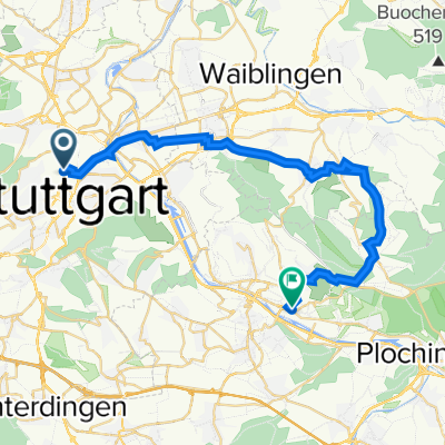
Route template
Stuttgart to Esslingen am Neckar

- 1 h 4 min
- Duration
- 16.7 km
- Distance
- 42 m
- Ascent
- 55 m
- Descent
- 15.7 km/h
- Avg. speed
- 260 m
- Max. altitude
Hop on your bike for a delightful ride from the bustling streets of Stuttgart to the charming town of Esslingen am Neckar! This scenic route stretches just over 16 kilometers, making it perfect for a leisurely afternoon ride.
You'll start in Stuttgart, known for its vibrant cultural scene and as the hub of the German automotive industry. As you pedal away from the city, get ready to enjoy a mostly smooth ride on asphalt paths, with a sprinkle of charming paved sections that add to the experience.
The route is incredibly varied, taking you along peaceful paths and quiet roads. There's only a slight ascent and a gentle descent, ensuring a relaxed ride without too much effort. Along the way, you'll be enveloped by beautiful landscapes and possibly catch the refreshing breeze from the nearby Neckar River.
As you arrive in Esslingen am Neckar, you'll find yourself in a town rich in medieval history, complete with half-timbered houses and a picturesque old town. Take a moment to explore the local cafes or enjoy a stroll along the riverbanks before heading back or onward on your next adventure. Happy cycling!
Community
Top users in this region


From our community
The best bike routes from Stuttgart to Esslingen am Neckar

Betriebsausflug sportlich
Cycling route in Stuttgart, Baden-Württemberg, Germany
- 23.8 km
- Distance
- 288 m
- Ascent
- 316 m
- Descent

Betriebsausflug 2009 - hügelige Radtour
Cycling route in Stuttgart, Baden-Württemberg, Germany
- 24.8 km
- Distance
- 335 m
- Ascent
- 363 m
- Descent

Tandem 2020 Test gesamt
Cycling route in Stuttgart, Baden-Württemberg, Germany
- 707.3 km
- Distance
- 1,736 m
- Ascent
- 1,776 m
- Descent

Betriebsausflug 2009 - gemütliche Radtour
Cycling route in Stuttgart, Baden-Württemberg, Germany
- 26.4 km
- Distance
- 158 m
- Ascent
- 387 m
- Descent

Tandem 2020 Test 2 K.H. Route
Cycling route in Stuttgart, Baden-Württemberg, Germany
- 811 km
- Distance
- 1,757 m
- Ascent
- 1,902 m
- Descent

Birkenwaldstraße 93, Stuttgart nach Küferstraße 24, Esslingen am Neckar
Cycling route in Stuttgart, Baden-Württemberg, Germany
- 15.9 km
- Distance
- 33 m
- Ascent
- 136 m
- Descent

Kaltental- Obertürkheim Variante 2
Cycling route in Stuttgart, Baden-Württemberg, Germany
- 17.9 km
- Distance
- 191 m
- Ascent
- 311 m
- Descent

C5 abholen
Cycling route in Stuttgart, Baden-Württemberg, Germany
- 29.9 km
- Distance
- 452 m
- Ascent
- 469 m
- Descent

Hanfländerstraße 14/1, Stuttgart nach Kanalstraße 55, Esslingen am Neckar
Cycling route in Stuttgart, Baden-Württemberg, Germany
- 16.8 km
- Distance
- 197 m
- Ascent
- 325 m
- Descent

Esslingen von Hohenzollern
Cycling route in Stuttgart, Baden-Württemberg, Germany
- 17.4 km
- Distance
- 43 m
- Ascent
- 90 m
- Descent

Robert-Leicht-Straße 169, Stuttgart nach Uhlbacher Straße 23, Stuttgart
Cycling route in Stuttgart, Baden-Württemberg, Germany
- 14.8 km
- Distance
- 177 m
- Ascent
- 385 m
- Descent

Arbeit Hinweg
Cycling route in Stuttgart, Baden-Württemberg, Germany
- 11.1 km
- Distance
- 42 m
- Ascent
- 80 m
- Descent
Discover more routes
 Tandem 2020 Test 2 K.H. Route
- Distance
- 811 km
- Ascent
- 1,757 m
- Descent
- 1,902 m
- Location
- Stuttgart, Baden-Württemberg, Germany
 Birkenwaldstraße 93, Stuttgart nach Küferstraße 24, Esslingen am Neckar
- Distance
- 15.9 km
- Ascent
- 33 m
- Descent
- 136 m
- Location
- Stuttgart, Baden-Württemberg, Germany
 Kaltental- Obertürkheim Variante 2
- Distance
- 17.9 km
- Ascent
- 191 m
- Descent
- 311 m
- Location
- Stuttgart, Baden-Württemberg, Germany
 C5 abholen
- Distance
- 29.9 km
- Ascent
- 452 m
- Descent
- 469 m
- Location
- Stuttgart, Baden-Württemberg, Germany
 Hanfländerstraße 14/1, Stuttgart nach Kanalstraße 55, Esslingen am Neckar
- Distance
- 16.8 km
- Ascent
- 197 m
- Descent
- 325 m
- Location
- Stuttgart, Baden-Württemberg, Germany
 Esslingen von Hohenzollern
- Distance
- 17.4 km
- Ascent
- 43 m
- Descent
- 90 m
- Location
- Stuttgart, Baden-Württemberg, Germany
 Robert-Leicht-Straße 169, Stuttgart nach Uhlbacher Straße 23, Stuttgart
- Distance
- 14.8 km
- Ascent
- 177 m
- Descent
- 385 m
- Location
- Stuttgart, Baden-Württemberg, Germany
 Arbeit Hinweg
- Distance
- 11.1 km
- Ascent
- 42 m
- Descent
- 80 m
- Location
- Stuttgart, Baden-Württemberg, Germany
Routes from Stuttgart
Cycling day trip from
Stuttgart to Sindelfingen
Quick ride by bicycle from
Stuttgart to Stuttgart-Ost
Quick ride by bicycle from
Stuttgart to Leinfelden-Echterdingen
Routes to Esslingen am Neckar
Cycling day trip from
Tübingen to Esslingen am Neckar
Quick ride by bicycle from
Stuttgart-Ost to Esslingen am Neckar
Quick ride by bicycle from
Leinfelden-Echterdingen to Esslingen am Neckar