
Route template
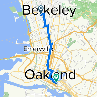
Berkeley to Oakland

- 37 min
- Duration
- 10.7 km
- Distance
- 83 m
- Ascent
- 110 m
- Descent
- 17.2 km/h
- Avg. speed
- 60 m
- Max. altitude
Kick off your cycling adventure in the vibrant city of Berkeley, known for its prestigious university and bohemian charm. As you pedal out, you'll find yourself surrounded by tree-lined streets and iconic views of the San Francisco Bay.
Your journey to Oakland is a pleasant and easy-going ride of just under 11 kilometers. It's mostly smooth sailing on asphalt surfaces with a gentle ascent and some rolling hills to keep things interesting. Thankfully, 94% of your path will take you along quiet roads - perfect for a peaceful ride without much car traffic to worry about.
As you approach Oakland, the city's dynamic art scene and culturally diverse neighborhoods warm up to you. Known as the Brooklyn of the West, Oakland is a hub of creativity with a lively atmosphere and fantastic food scene. Soon after your ride concludes, you can catch a cool breath by Lake Merritt or explore the local coffee shops and eateries.
So, gear up and enjoy this leisurely ride from the academic spirit of Berkeley to the artistic vibes of Oakland. It's a delightful journey that offers a mix of natural beauty and urban charm.
Community
Top users in this region


From our community
The best bike routes from Berkeley to Oakland

Grizzly to Lake Merrit
Cycling route in Berkeley, California, United States of America
- 12.4 km
- Distance
- 13 m
- Ascent
- 329 m
- Descent

Recovered Route
Cycling route in Berkeley, California, United States of America
- 5.9 km
- Distance
- 46 m
- Ascent
- 93 m
- Descent

Allston Way 2001, Berkeley to 13th Street 320, Oakland
Cycling route in Berkeley, California, United States of America
- 24.6 km
- Distance
- 960 m
- Ascent
- 1,003 m
- Descent

Dunn to Brenner
Cycling route in Berkeley, California, United States of America
- 5.9 km
- Distance
- 11 m
- Ascent
- 71 m
- Descent

hill bomb to merritt
Cycling route in Berkeley, California, United States of America
- 26.4 km
- Distance
- 621 m
- Ascent
- 714 m
- Descent

Workk
Cycling route in Berkeley, California, United States of America
- 6.2 km
- Distance
- 46 m
- Ascent
- 48 m
- Descent

2150 Shattuck Ave, Berkeley to 180 2nd St, Oakland
Cycling route in Berkeley, California, United States of America
- 10.1 km
- Distance
- 22 m
- Ascent
- 74 m
- Descent

2107 Hearst Ave, Berkeley to 180 2nd St, Oakland
Cycling route in Berkeley, California, United States of America
- 10.5 km
- Distance
- 54 m
- Ascent
- 114 m
- Descent

2800 Park St, Berkeley to 502–532 Wesley Ave, Oakland
Cycling route in Berkeley, California, United States of America
- 8.3 km
- Distance
- 45 m
- Ascent
- 51 m
- Descent

5951 College Ave, Oakland to 2311 Ivy Dr, Oakland
Cycling route in Berkeley, California, United States of America
- 8.2 km
- Distance
- 60 m
- Ascent
- 96 m
- Descent

Allston Way 1409, Berkeley to Fallon Street 900, Oakland
Cycling route in Berkeley, California, United States of America
- 10 km
- Distance
- 33 m
- Ascent
- 57 m
- Descent

Claremont to Clay Ferry
Cycling route in Berkeley, California, United States of America
- 9.3 km
- Distance
- 53 m
- Ascent
- 177 m
- Descent
Discover more routes
 hill bomb to merritt
- Distance
- 26.4 km
- Ascent
- 621 m
- Descent
- 714 m
- Location
- Berkeley, California, United States of America
 Workk
Workk- Distance
- 6.2 km
- Ascent
- 46 m
- Descent
- 48 m
- Location
- Berkeley, California, United States of America
 2150 Shattuck Ave, Berkeley to 180 2nd St, Oakland
- Distance
- 10.1 km
- Ascent
- 22 m
- Descent
- 74 m
- Location
- Berkeley, California, United States of America
 2107 Hearst Ave, Berkeley to 180 2nd St, Oakland
- Distance
- 10.5 km
- Ascent
- 54 m
- Descent
- 114 m
- Location
- Berkeley, California, United States of America
 2800 Park St, Berkeley to 502–532 Wesley Ave, Oakland
- Distance
- 8.3 km
- Ascent
- 45 m
- Descent
- 51 m
- Location
- Berkeley, California, United States of America
 5951 College Ave, Oakland to 2311 Ivy Dr, Oakland
- Distance
- 8.2 km
- Ascent
- 60 m
- Descent
- 96 m
- Location
- Berkeley, California, United States of America
 Allston Way 1409, Berkeley to Fallon Street 900, Oakland
- Distance
- 10 km
- Ascent
- 33 m
- Descent
- 57 m
- Location
- Berkeley, California, United States of America
 Claremont to Clay Ferry
- Distance
- 9.3 km
- Ascent
- 53 m
- Descent
- 177 m
- Location
- Berkeley, California, United States of America
Routes from Berkeley
Quick ride by bicycle from
Berkeley to Emeryville