
Cycling day trip from Vysoké Tatry to Ždiar
Customize your own route based on our template or discover how our community prefers to cycle from Vysoké Tatry to Ždiar.
Route template
Vysoké Tatry to Ždiar
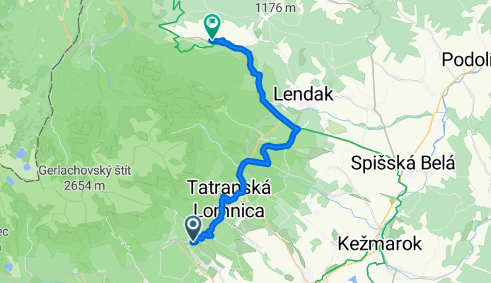
- 2 h 1 min
- Duration
- 27.5 km
- Distance
- 566 m
- Ascent
- 581 m
- Descent
- 13.6 km/h
- Avg. speed
- 930 m
- Max. altitude
Kick off your cycling adventure in the stunning Vysoké Tatry, known for its breathtaking landscapes and exhilarating hiking opportunities. This route takes you through the picturesque region towards the charming village of Ždiar, all in around 27.5 kilometers. It's mostly a smooth ride with just the right amount of challenge—expect some ascent and descent along the way to keep things interesting.
The track is primarily composed of scenic cycleways and tracks, ensuring plenty of beautiful views. You’ll glide over a mix of asphalt and gravel surfaces, with some loose gravel thrown in for a bit of added texture. Fortunately, there’s hardly a busy road in sight—just lots of quiet stretches perfect for soaking in the fresh mountain air.
As you journey towards Ždiar, enjoy the delightful mix of traditional Slovak architecture and stunning natural scenery. Ždiar is a quaint village nestled in the Belianske Tatras, offering a peek into Slovak culture with its colorful wooden houses and fascinating folklore museum.
Whether you're an avid cyclist or just out for a leisurely ride, this route offers a delightful blend of rural serenity and natural beauty. Don't forget to pause and enjoy the panoramic mountain views along the way!
Community
Top users in this region


From our community
The best bike routes from Vysoké Tatry to Ždiar

Chata Pri Zelenom Plese
Cycling route in Vysoké Tatry, Prešovský kraj, Slovak Republic
- 11 km
- Distance
- 734 m
- Ascent
- 36 m
- Descent

2022 - IL - day6 - Tatranská Lomnica - Zelené pleso and back
Cycling route in Vysoké Tatry, Prešovský kraj, Slovak Republic
- 10.8 km
- Distance
- 715 m
- Ascent
- 21 m
- Descent

Biela voda-2869-8866-8863-2870-Zdiar-MTB
Cycling route in Vysoké Tatry, Prešovský kraj, Slovak Republic
- 28.8 km
- Distance
- 534 m
- Ascent
- 518 m
- Descent

Tatry 2010 - Tatranské Matliare - Tatranská Javorina
Cycling route in Vysoké Tatry, Prešovský kraj, Slovak Republic
- 25.7 km
- Distance
- 574 m
- Ascent
- 452 m
- Descent

Tatranská Lomnica - Osturňa
Cycling route in Vysoké Tatry, Prešovský kraj, Slovak Republic
- 31.9 km
- Distance
- 491 m
- Ascent
- 595 m
- Descent

Tatranská Lomnica- Tatranská Javorina
Cycling route in Vysoké Tatry, Prešovský kraj, Slovak Republic
- 28 km
- Distance
- 519 m
- Ascent
- 366 m
- Descent

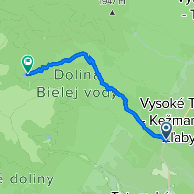
Projekt: 231108 5 km Dolina Kežmarskej Bielej vody
Cycling route in Vysoké Tatry, Prešovský kraj, Slovak Republic
- 4.8 km
- Distance
- 462 m
- Ascent
- 0 m
- Descent

zelene pleso
Cycling route in Vysoké Tatry, Prešovský kraj, Slovak Republic
- 10.5 km
- Distance
- 721 m
- Ascent
- 27 m
- Descent

cesta na zelene pleso
Cycling route in Vysoké Tatry, Prešovský kraj, Slovak Republic
- 7.6 km
- Distance
- 622 m
- Ascent
- 0 m
- Descent

Tatry Tour mała runda
Cycling route in Vysoké Tatry, Prešovský kraj, Slovak Republic
- 36.3 km
- Distance
- 528 m
- Ascent
- 555 m
- Descent

Zöld-tó Tátra
Cycling route in Vysoké Tatry, Prešovský kraj, Slovak Republic
- 7.6 km
- Distance
- 622 m
- Ascent
- 0 m
- Descent

Tatranská Lomnica 287, Vysoké Tatry do Vysoké Tatry
Cycling route in Vysoké Tatry, Prešovský kraj, Slovak Republic
- 47.6 km
- Distance
- 683 m
- Ascent
- 760 m
- Descent
Discover more routes
 Tatranská Lomnica - Osturňa
- Distance
- 31.9 km
- Ascent
- 491 m
- Descent
- 595 m
- Location
- Vysoké Tatry, Prešovský kraj, Slovak Republic
 Tatranská Lomnica- Tatranská Javorina
- Distance
- 28 km
- Ascent
- 519 m
- Descent
- 366 m
- Location
- Vysoké Tatry, Prešovský kraj, Slovak Republic
 Projekt: 231108 5 km Dolina Kežmarskej Bielej vody
- Distance
- 4.8 km
- Ascent
- 462 m
- Descent
- 0 m
- Location
- Vysoké Tatry, Prešovský kraj, Slovak Republic
 zelene pleso
- Distance
- 10.5 km
- Ascent
- 721 m
- Descent
- 27 m
- Location
- Vysoké Tatry, Prešovský kraj, Slovak Republic
 cesta na zelene pleso
- Distance
- 7.6 km
- Ascent
- 622 m
- Descent
- 0 m
- Location
- Vysoké Tatry, Prešovský kraj, Slovak Republic
 Tatry Tour mała runda
- Distance
- 36.3 km
- Ascent
- 528 m
- Descent
- 555 m
- Location
- Vysoké Tatry, Prešovský kraj, Slovak Republic
 Zöld-tó Tátra
- Distance
- 7.6 km
- Ascent
- 622 m
- Descent
- 0 m
- Location
- Vysoké Tatry, Prešovský kraj, Slovak Republic
 Tatranská Lomnica 287, Vysoké Tatry do Vysoké Tatry
- Distance
- 47.6 km
- Ascent
- 683 m
- Descent
- 760 m
- Location
- Vysoké Tatry, Prešovský kraj, Slovak Republic