Premium Badge Download on the App Store Get it on Google Play Turn-by-turn Navigation Offline Maps Bike Type Optimized Routing Premium Maps Custom Bike Computer Export Routes Route Previews Fall Detection Premium Support

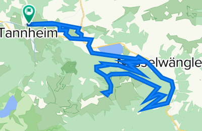
Cycling Route in Tannheim, Tyrol, Austria

RSC TTal - Krinnenspitze

0
Open this route in the Bikemap app

Open this route in the Bikemap app

Open this route in Bikemap Web

Open this route in Bikemap Web

37 km
Distance
1827 m
Ascent
1827 m
Descent
-:-- h
Duration
-- km/h
Avg. Speed
1727 m
Max. Elevation

About This Route

37km / 800Hm

Pause: Gräner Odenalpe (km 17)

This route is based on MTB - Krinnenspitze (BGA34) - Tannheim .

Customize this cycling route with the Bikemap route planner.

Make it yours!

Did you know? You can use this route as a template in our cycling route planner if you don't wish to start from scratch. Customize it based on your needs to plan your perfect cycling tour.

Open it in the app