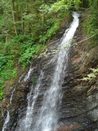
<span style="font-family: Symbol; mso-fareast-font-family: Symbol; mso-bidi-font-family: Symbol; color: black; mso-ansi-language: EN-US; mso-fareast-language: RU;" lang="EN-US"><span style="mso-list: Ignore;">·<span style="font: 7.0pt "Times New Roman";"> </span></span></span><span style="mso-fareast-font-family: "Times New Roman"; mso-bidi-font-family: "Times New Roman"; color: black; mso-ansi-language: EN-US; mso-fareast-language: RU;" lang="EN-US">Huk waterfall.</span><span style="mso-fareast-font-family: "Times New Roman"; mso-bidi-font-family: "Times New Roman"; color: black; mso-fareast-language: RU;"> </span><span style="mso-fareast-font-family: "Times New Roman"; mso-bidi-font-family: "Times New Roman"; color: black; mso-ansi-language: EN-US; mso-fareast-language: RU;" lang="EN-US">Almost every third
waterfall in the Carpathians is called Huk (may be translated as “loud”). So
let’s call this particular one situated at the distance of several km from
Mykulychyn Huk Zhenetskyi as this turbulent 15m-high waterfall is situated on
the Zhenets river. <span style="mso-spacerun: yes;"> </span><span style="mso-spacerun: yes;"> </span></span>
<span style="font-family: Symbol; mso-fareast-font-family: Symbol; mso-bidi-font-family: Symbol; color: black; mso-ansi-language: EN-US; mso-fareast-language: RU;" lang="EN-US"><span style="mso-list: Ignore;">·<span style="font: 7.0pt "Times New Roman";"> </span></span></span><span style="mso-fareast-font-family: "Times New Roman"; mso-bidi-font-family: "Times New Roman"; color: black; mso-ansi-language: EN-US; mso-fareast-language: RU;" lang="EN-US">Railway arched bridge
(viaduct). One of the oldest and the longest stone arched bridges of Europe is
situated in Vorokhta (130 m) and the length of one of the arches is 65 m. This
famous railway bridge was built in 1894 and operated till 2000. There is also
one of the oldest 17<sup>th</sup>-century wooden churches – the church of St.
Virgin’s Nativity preserved in Vorokhta. </span>
<span style="font-family: Symbol; mso-fareast-font-family: Symbol; mso-bidi-font-family: Symbol; color: black; mso-ansi-language: EN-US; mso-fareast-language: RU;" lang="EN-US"><span style="mso-list: Ignore;">·<span style="font: 7.0pt "Times New Roman";"> </span></span></span><span style="mso-fareast-font-family: "Times New Roman"; mso-bidi-font-family: "Times New Roman"; color: black; mso-ansi-language: EN-US; mso-fareast-language: RU;" lang="EN-US">Yablunytskyi pass (Tatarsky
pass) – 931 m above the sea. Here you’ll visit the souvenir market known not
only in the Carpathians but in the whole Ukraine. In Tatariv we will stop at
the monument of the period of World War I.</span>