Premium Badge Download on the App Store Get it on Google Play Turn-by-turn Navigation Offline Maps Bike Type Optimized Routing Premium Maps Custom Bike Computer Export Routes Route Previews Fall Detection Premium Support

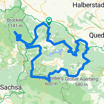
Cycling Route in Wernigerode, Saxony-Anhalt, Germany

Stauseetour 134 KM

2
Open this route in the Bikemap app

Open this route in the Bikemap app

Open this route in Bikemap Web

Open this route in Bikemap Web

134 km
Distance
1245 m
Ascent
1245 m
Descent
-:-- h
Duration
-- km/h
Avg. Speed
--- m
Max. Elevation

About This Route

Start in Wernigerode - Königshütte - Elend - Braunlage - Bruchberg - Altenau - Okerstausee - Bocksberg - Granestausee - Gosslar - Wülpenrode - Lütgenrode - Veckenstedt - Wernigerode

Die Tour ist auf 2 Tage ausgelegt, da 70 KM im Gelände pro Tag durchaus machbar sind und man so die Landschaft und auch Sehenwürdigkeiten genießen kann.

Die Strecke ist mit sämtlichen Stauseen und Teichen angelegt.

Übernachtung ist angesetzt in D-38707 Altenau.

This cycling route is ideal for: MTB

You will cycle on the following surfaces: Paved Unpaved Gravel

Customize this cycling route with the Bikemap route planner.

Make it yours!

Did you know? You can use this route as a template in our cycling route planner if you don't wish to start from scratch. Customize it based on your needs to plan your perfect cycling tour.

Open it in the app