Premium Badge Download on the App Store Get it on Google Play Turn-by-turn Navigation Offline Maps Bike Type Optimized Routing Premium Maps Custom Bike Computer Export Routes Route Previews Fall Detection Premium Support

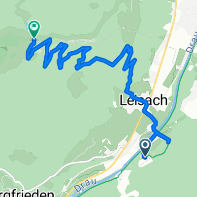
Cycling Route in Leisach, Tyrol, Austria

Wilferner-Tal + Pustertaler Almweg

0
Open this route in the Bikemap app

Open this route in the Bikemap app

Open this route in Bikemap Web

Open this route in Bikemap Web

25 km
Distance
1362 m
Ascent
1352 m
Descent
-:-- h
Duration
-- km/h
Avg. Speed
--- m
Max. Elevation

About This Route

Auf den Waldwegen Achtung auf Forstarbeiten!

Die Tour führt zuerst auf der Pustertaler Höhenstraße bis Oberthal, dann auf einem steilen Schotterweg bis zur "Waldhuber-Kaser". Anschließen Schiebestrecke entlang des Pustertaler Almwegs (teilw. befahrbar). Von Mair-Kaser auf einem guten Forstweg zurück zum Ortsteil "Dörfl.

Von Dort auf Asphalt über Schrottendorf und Klausen zurück nach Oberthal. Wer die Abzweigung nach St. Corbinian trifft kann noch ein Stück Schotterweg Richtung Tal fahren. Danach auf Nebenstraßen zurcük zum Ausgangspunkt.

This cycling route is ideal for: MTB

You will cycle on the following surfaces: Paved Unpaved Gravel

Customize this cycling route with the Bikemap route planner.

Make it yours!

Did you know? You can use this route as a template in our cycling route planner if you don't wish to start from scratch. Customize it based on your needs to plan your perfect cycling tour.

Open it in the app