

In der Riedmark von Franz H.
A cycling route starting in Linz, Upper Austria, Austria.
Overview
About this route
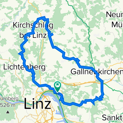
Diese Route ist ein Schmankerl unter vielen Möglichkeiten das Mühlviertel mit dem Rad zu erkunden. Sie bietet viele Aussichtpunkte in die Landschaft. Dabei muß besonders der Punkt der südlichsten Wasserscheide in Lichtenstein beim Hungerlehnerhof erwähnt werden. Auch für einen Besuch der Aussichtswarte am Roadlberg in Wintersdorf sollte Zeit sein. Als Mittagsrast bietet sich das Gasthaus Berger in Ottenschlag an, das für seine Kardinalschnitten berühmt ist. Die Tour kann von den konditionellen Anforderungen her als sehr fordernd bezeichnet werden. Mehr als die Hälfte der Tour verläuft auf verkehrsarmen Straßen oder Güterwegen.
- -:--
- Duration
- 65.6 km
- Distance
- 1,299 m
- Ascent
- 1,283 m
- Descent
- ---
- Avg. speed
- 845 m
- Avg. speed

Route quality
Waytypes & surfaces along the route
Waytypes
Quiet road
28.5 km
(43 %)
Road
28 km
(43 %)
Surfaces
Paved
26.2 km
(40 %)
Unpaved
0.6 km
(<1 %)
Asphalt
26.2 km
(40 %)
Gravel
0.6 km
(<1 %)
Continue with Bikemap
Use, edit, or download this cycling route
You would like to ride In der Riedmark von Franz H. or customize it for your own trip? Here is what you can do with this Bikemap route:
Free features
- Save this route as favorite or in collections
- Copy & plan your own version of this route
- Sync your route with Garmin or Wahoo
Premium features
Free trial for 3 days, or one-time payment. More about Bikemap Premium.
- Navigate this route on iOS & Android
- Export a GPX / KML file of this route
- Create your custom printout (try it for free)
- Download this route for offline navigation
Discover more Premium features.
Get Bikemap PremiumFrom our community
Other popular routes starting in Linz
 4.3.2023
- Distance
- 47.5 km
- Ascent
- 751 m
- Descent
- 749 m
- Location
- Linz, Upper Austria, Austria
 St. Martin- Lichtenhah-Lichtenberg
- Distance
- 73.2 km
- Ascent
- 1,240 m
- Descent
- 1,241 m
- Location
- Linz, Upper Austria, Austria
 Eine kleine Runde bei Linz
- Distance
- 21.4 km
- Ascent
- 541 m
- Descent
- 444 m
- Location
- Linz, Upper Austria, Austria
 Trail GIS – Bachlberg Variante01
- Distance
- 21.7 km
- Ascent
- 713 m
- Descent
- 850 m
- Location
- Linz, Upper Austria, Austria
 Lichtenberg, Mirellental, Pfenningberg CLONED FROM ROUTE 38001
- Distance
- 54.3 km
- Ascent
- 1,090 m
- Descent
- 1,093 m
- Location
- Linz, Upper Austria, Austria
 Giselawarte - GIS
- Distance
- 27.7 km
- Ascent
- 914 m
- Descent
- 834 m
- Location
- Linz, Upper Austria, Austria
 Pfenningberg Tour
- Distance
- 28.9 km
- Ascent
- 458 m
- Descent
- 458 m
- Location
- Linz, Upper Austria, Austria
 plesching
- Distance
- 32.6 km
- Ascent
- 325 m
- Descent
- 326 m
- Location
- Linz, Upper Austria, Austria
Open it in the app