

Feuerkogel
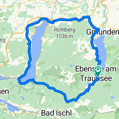
A cycling route starting in Ebensee, Upper Austria, Austria.
Overview
About this route
Feuerkogel (der Ebenseer Hausberg.)
Suchst du die ultimative steile Herausforderung, dann bist du hir richtig. Schicke deine Familie mit der Seilbahn hoch, die können die schöne Aussicht am Hochplato genießen oder einfach nur die Sonne im Gastgarten, wärden du dich die 9 Km und ca 1200 Höhenmeter Stollen für Stollen hochkämpst. Wenn du die ersten paar Kilometer glaubst es ist steil, blos weil du mit der Gewichtsverteilung zwischen hochsteigenden Vorderrad und durchdrehendem Hinterrad nur mit Mühe findest, so freue dich auf die letzten Kilometer. Da wirds noch steiler und die Strasse noch schlechter. Es ist keine Schande hier zu schieben. Runterfahren ist auch nicht leichter. Sage nicht ich habe dich nicht gewarnt.
Eben eine echte Herausforderung für jeden MTB`ler. Ist er zu Stark - bist du zu schwach ;o)
Viel Spaß an meiner Hausstrecke.
- -:--
- Duration
- 25.1 km
- Distance
- 1,229 m
- Ascent
- 1,228 m
- Descent
- ---
- Avg. speed
- ---
- Avg. speed
Route quality
Waytypes & surfaces along the route
Waytypes
Track
18.5 km
(74 %)
Road
6.5 km
(26 %)
Surfaces
Paved
6.8 km
(27 %)
Unpaved
18.4 km
(73 %)
Gravel
18.2 km
(73 %)
Asphalt
6.8 km
(27 %)
Continue with Bikemap
Use, edit, or download this cycling route
You would like to ride Feuerkogel or customize it for your own trip? Here is what you can do with this Bikemap route:
Free features
- Save this route as favorite or in collections
- Copy & plan your own version of this route
- Sync your route with Garmin or Wahoo
Premium features
Free trial for 3 days, or one-time payment. More about Bikemap Premium.
- Navigate this route on iOS & Android
- Export a GPX / KML file of this route
- Create your custom printout (try it for free)
- Download this route for offline navigation
Discover more Premium features.
Get Bikemap PremiumFrom our community
Other popular routes starting in Ebensee
 Lueg - Langbathseen von Traunkirchen
- Distance
- 36.1 km
- Ascent
- 490 m
- Descent
- 490 m
- Location
- Ebensee, Upper Austria, Austria
 3-Seen-Tour -Über die Langbathseen zum Traunsee
- Distance
- 34 km
- Ascent
- 0 m
- Descent
- 0 m
- Location
- Ebensee, Upper Austria, Austria
 Langbathseerunde
- Distance
- 44.2 km
- Ascent
- 862 m
- Descent
- 862 m
- Location
- Ebensee, Upper Austria, Austria
 Trauneck 4, Ebensee nach Vogelsangweg 1, Traunkirchen
- Distance
- 37.6 km
- Ascent
- 488 m
- Descent
- 485 m
- Location
- Ebensee, Upper Austria, Austria
 offensee langbarthseen
- Distance
- 68.2 km
- Ascent
- 946 m
- Descent
- 936 m
- Location
- Ebensee, Upper Austria, Austria
 2021_Salzkammergut_Et.9
- Distance
- 71.5 km
- Ascent
- 1,158 m
- Descent
- 1,155 m
- Location
- Ebensee, Upper Austria, Austria
 Attersee Runde
- Distance
- 97.6 km
- Ascent
- 751 m
- Descent
- 753 m
- Location
- Ebensee, Upper Austria, Austria
 Attersee Runde
- Distance
- 97.2 km
- Ascent
- 1,446 m
- Descent
- 1,477 m
- Location
- Ebensee, Upper Austria, Austria
Open it in the app