

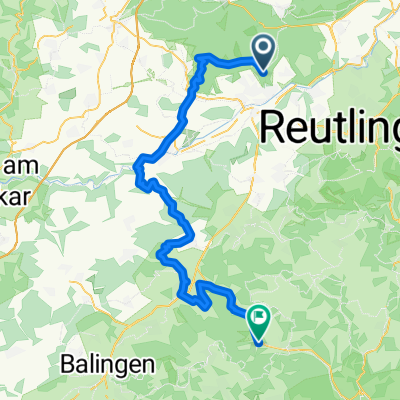
MTB-Tour Heuberger Tor - Ruine Müneck
A cycling route starting in Tübingen, Baden-Wurttemberg, Germany.
Overview
About this route
Round tour from Heuberger Gate to Müneck Ruin and back. A few nice trails included.
- -:--
- Duration
- 27.4 km
- Distance
- 300 m
- Ascent
- 303 m
- Descent
- ---
- Avg. speed
- ---
- Max. altitude
Continue with Bikemap
Use, edit, or download this cycling route
You would like to ride MTB-Tour Heuberger Tor - Ruine Müneck or customize it for your own trip? Here is what you can do with this Bikemap route:
Free features
- Save this route as favorite or in collections
- Copy & plan your own version of this route
- Sync your route with Garmin or Wahoo
Premium features
Free trial for 3 days, or one-time payment. More about Bikemap Premium.
- Navigate this route on iOS & Android
- Export a GPX / KML file of this route
- Create your custom printout (try it for free)
- Download this route for offline navigation
Discover more Premium features.
Get Bikemap PremiumFrom our community
Other popular routes starting in Tübingen
 T Ruine Mundeck und mehr
- Distance
- 47.9 km
- Ascent
- 589 m
- Descent
- 598 m
- Location
- Tübingen, Baden-Wurttemberg, Germany
 2017-02-01-H-Hirsch-Vitalia-A
- Distance
- 8.3 km
- Ascent
- 136 m
- Descent
- 138 m
- Location
- Tübingen, Baden-Wurttemberg, Germany
 Tübingen - Burladingen
- Distance
- 49.3 km
- Ascent
- 885 m
- Descent
- 718 m
- Location
- Tübingen, Baden-Wurttemberg, Germany
 2017-02-03-H-Hirsch-REWE-Markt-CoBa-Alnatura-Hirsch-A
- Distance
- 13.2 km
- Ascent
- 147 m
- Descent
- 149 m
- Location
- Tübingen, Baden-Wurttemberg, Germany
 Tübingen - Joggingrunde für Mama und Papa
- Distance
- 15.1 km
- Ascent
- 320 m
- Descent
- 321 m
- Location
- Tübingen, Baden-Wurttemberg, Germany
 Tübingen - Burladingen
- Distance
- 64.2 km
- Ascent
- 709 m
- Descent
- 389 m
- Location
- Tübingen, Baden-Wurttemberg, Germany
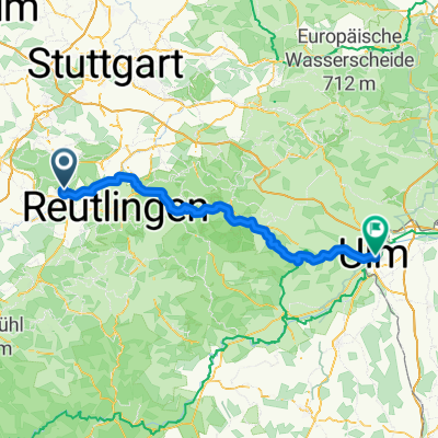 Tübingen to Ulm via Blaubeuren
- Distance
- 99.1 km
- Ascent
- 1,568 m
- Descent
- 1,543 m
- Location
- Tübingen, Baden-Wurttemberg, Germany
 ETT 2022 Gesamte Strecke
- Distance
- 877.3 km
- Ascent
- 6,381 m
- Descent
- 6,375 m
- Location
- Tübingen, Baden-Wurttemberg, Germany
Open it in the app