Premium Badge Download on the App Store Get it on Google Play Turn-by-turn Navigation Offline Maps Bike Type Optimized Routing Premium Maps Custom Bike Computer Export Routes Route Previews Fall Detection Premium Support

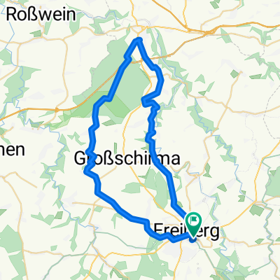
Cycling Route in Freiberg, Saxony, Germany

Runde durch den Tharandter Wald

0
Open this route in the Bikemap app

Open this route in the Bikemap app

Open this route in Bikemap Web

Open this route in Bikemap Web

38 km
Distance
559 m
Ascent
529 m
Descent
-:-- h
Duration
-- km/h
Avg. Speed
--- m
Max. Elevation

About This Route

Schöne ausdauernde Route. Etwa 3 Stunden zu fahren, bei gemäßigtem Tempo.  Bitte Marker beachten! ;)

This cycling route is ideal for: MTB

You will cycle on the following surfaces: Paved Unpaved Gravel

Highlights Along The Route

Point of Interest

Besagtes Trage-stück

Point of Interest

auch etwas unwegsam, wie der weg weitergeht ist schwer zu entdecken! Augen auf und ausnahmsweiße der karte vertrauen.. oder: Weg ändern!

Point of Interest

Alternativer Weg, um Unanehmlichkeiten zu vermeiden ;)

Customize this cycling route with the Bikemap route planner.

Make it yours!

Did you know? You can use this route as a template in our cycling route planner if you don't wish to start from scratch. Customize it based on your needs to plan your perfect cycling tour.

Open it in the app