Premium Badge Download on the App Store Get it on Google Play Turn-by-turn Navigation Offline Maps Bike Type Optimized Routing Premium Maps Custom Bike Computer Export Routes Route Previews Fall Detection Premium Support

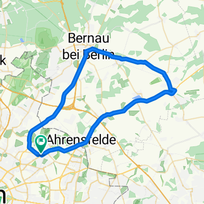
Cycling Route in Neu-Hohenschönhausen, Land Berlin, Germany

Rundkurs in Neu-Hsh

1
Open this route in the Bikemap app

Open this route in the Bikemap app

Open this route in Bikemap Web

Open this route in Bikemap Web

15 km
Distance
37 m
Ascent
38 m
Descent
-:-- h
Duration
-- km/h
Avg. Speed
--- m
Max. Elevation

About This Route

fährt sich gut da relativ wenig Ampeln, bei vorausschauender Fahrweise kaum Stops.

Davon 2-3 Rd. nach Feierabend dann paßt es Das Tool kennt aber nicht den kleinen Dahmeweg hinter der Feuerwache kurz vor

MediMax. Der geht rechts ab, dann unter die

S-Bahnbrücke nach rechts und dann nur noch geradeaus bis zur Bitterfelder.

This cycling route is ideal for: Road bike

You will cycle on the following surfaces: Paved

Customize this cycling route with the Bikemap route planner.

Make it yours!

Did you know? You can use this route as a template in our cycling route planner if you don't wish to start from scratch. Customize it based on your needs to plan your perfect cycling tour.

Open it in the app