Premium Badge Download on the App Store Get it on Google Play Turn-by-turn Navigation Offline Maps Bike Type Optimized Routing Premium Maps Custom Bike Computer Export Routes Route Previews Fall Detection Premium Support

Cycling Route in Germering, Bavaria, Germany

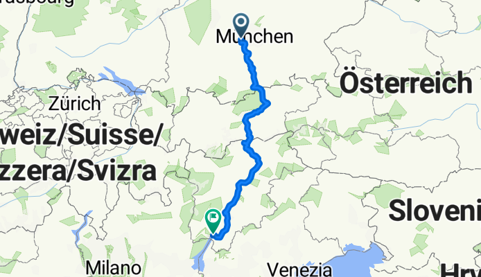
Germering - Achensee - Benner - Gardasee CLONED FROM ROUTE 851781

0
Open this route in the Bikemap app

Open this route in the Bikemap app

Open this route in Bikemap Web

Open this route in Bikemap Web

490 km
Distance
1913 m
Ascent
2384 m
Descent
-:-- h
Duration
-- km/h
Avg. Speed
--- m
Max. Elevation

About This Route

Von Schäftlarn bis ins Inntal auf dem neuen Radweg Via Bavarica Tyrolensis: viel Schotterweg, neben der Isar sehr gut geführt, beim Sylvensteinstausee sind wir auf der Bundesstraße gefahren (der Umweg über Falk soll sehr steil + voll Geröll sein).

Inntalradweg ist brettleben, ab Hall auf kleinen Landstraßen (alte Römerstrße) links auf der Talseite hoch, nur die letzten Km gibts keine Alternative zur Brennerbundesstraße.

Ab dem Brenner führt der völlig neu asphaltierte Radweg traumhaft schön durch Südtirol, sehr empfehlenswert!

ÜN in Achenkirch am Achensee / Pfons bei Matrei am Brenner / Brixen (da ist was los) / Trento (auch sehr interessant).

You will cycle on the following surfaces: Paved Gravel

Customize this cycling route with the Bikemap route planner.

Make it yours!

Did you know? You can use this route as a template in our cycling route planner if you don't wish to start from scratch. Customize it based on your needs to plan your perfect cycling tour.

Open it in the app