Premium Badge Download on the App Store Get it on Google Play Turn-by-turn Navigation Offline Maps Bike Type Optimized Routing Premium Maps Custom Bike Computer Export Routes Route Previews Fall Detection Premium Support

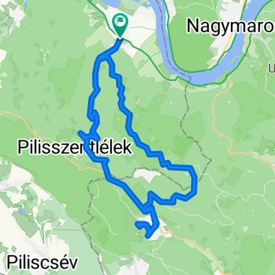
Cycling Route in Pilismarót, Komárom-Esztergom, Hungary

Tavaszi kezdés

0
Open this route in the Bikemap app

Open this route in the Bikemap app

Open this route in Bikemap Web

Open this route in Bikemap Web

62 km
Distance
532 m
Ascent
532 m
Descent
-:-- h
Duration
-- km/h
Avg. Speed
--- m
Max. Elevation

About This Route

<span style="color: #1f497d; mso-ascii-font-family: Calibri; mso-ascii-theme-font: minor-latin; mso-hansi-font-family: Calibri; mso-hansi-theme-font: minor-latin; mso-bidi-font-family: &apos; mso-bidi-theme-font: minor-bidi; mso-themecolor: dark2;"><span style="font-size: small;"><font face="Calibri">Az út <span style="mso-spacerun: yes;"> </span>nagy része aszfalton halad ezért tavaszra ajánlom, amikor még sáros az erdő.</font></span></span>

<span style="color: #1f497d; mso-ascii-font-family: Calibri; mso-ascii-theme-font: minor-latin; mso-hansi-font-family: Calibri; mso-hansi-theme-font: minor-latin; mso-bidi-font-family: &apos; mso-bidi-theme-font: minor-bidi; mso-themecolor: dark2;"><span style="font-size: small;"><font face="Calibri">Nagybörzsöny után van kb 1,5 km föld út (eső után nagy sár lehet) , illetve Nagyírtás puszta és Márianosztra közötti szakasz erdei turista út.</font></span></span>

This cycling route is ideal for: MTB

You will cycle on the following surfaces: Paved Unpaved

Customize this cycling route with the Bikemap route planner.

Make it yours!

Did you know? You can use this route as a template in our cycling route planner if you don't wish to start from scratch. Customize it based on your needs to plan your perfect cycling tour.

Open it in the app