Premium Badge Download on the App Store Get it on Google Play Turn-by-turn Navigation Offline Maps Bike Type Optimized Routing Premium Maps Custom Bike Computer Export Routes Route Previews Fall Detection Premium Support

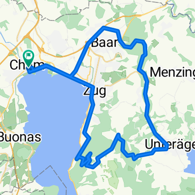
Cycling Route in Cham, Canton of Zug, Switzerland

Zugersee - Reppischtal - Mutschellen - Reusstal

7
Open this route in the Bikemap app

Open this route in the Bikemap app

Open this route in Bikemap Web

Open this route in Bikemap Web

72 km
Distance
776 m
Ascent
778 m
Descent
-:-- h
Duration
-- km/h
Avg. Speed
573 m
Max. Elevation

About This Route

Die landschaftlich grandiose Route führt bis auf wenige kurze Teilstrecken weit ab vom motorisierten Verkehr.

Mit Bikes oder Sportvelos fährt man statt nach Hedigen in der Talsenke auf Naturstrassen dem Bach entlang bis wieder zur Route im Würital.

Unter der Woche ist das untere Reppischtal durch militärische Schiessübungen manchmal gesperrt. Dann fährt man die Waffenplatzstrasse 2oo m hoch und dann links bis wieder zur Route.

Die Abfahrt nach Berikon, Militärstrasse - Zugerstrasse, sollt langsam gefahren werden, damit man das wunderschöne  Panorama geniessen kann.

Steigung total 590 Höhenmeter.

Auf Grund der Routenerkennung ist der Startpunkt verschoben. Er befindet sich beim Ziel, Bahnhof Cham.

This cycling route is ideal for: Road bike

You will cycle on the following surfaces: Paved

Customize this cycling route with the Bikemap route planner.

Make it yours!

Did you know? You can use this route as a template in our cycling route planner if you don't wish to start from scratch. Customize it based on your needs to plan your perfect cycling tour.

Open it in the app