Premium Badge Download on the App Store Get it on Google Play Turn-by-turn Navigation Offline Maps Bike Type Optimized Routing Premium Maps Custom Bike Computer Export Routes Route Previews Fall Detection Premium Support

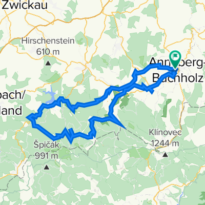
Cycling Route in Annaberg-Buchholz, Saxony, Germany

Talsperre Cranzahl

0
Open this route in the Bikemap app

Open this route in the Bikemap app

Open this route in Bikemap Web

Open this route in Bikemap Web

26 km
Distance
347 m
Ascent
354 m
Descent
-:-- h
Duration
-- km/h
Avg. Speed
--- m
Max. Elevation

About This Route

leider ist mit der Karte nicht alles möglich,und die Route wird nicht über Waldwege angezeigt. Diese sind aber teilweise gut ausgebaut, oder sogar geteert.

darum als Hinweis :

1. Unterwegs immer auf Schilder achten, die zBsp den Weg zur Talsperre anzeigen

2. parallel zur B95 verläuft auf dem Rückweg ein super Radweg, beginnend ab der Brücke über die Bahn. Dort nach rechts ab in den Wald (Schotterweg/Waldweg) und nach links dem alten Bahngleis folgen, bis dieser Weg auf den geteerten Radweg oberhalb Annaberg´s trifft .

This cycling route is ideal for: MTB City bike

You will cycle on the following surfaces: Unpaved

Customize this cycling route with the Bikemap route planner.

Make it yours!

Did you know? You can use this route as a template in our cycling route planner if you don't wish to start from scratch. Customize it based on your needs to plan your perfect cycling tour.

Open it in the app