Premium Badge Download on the App Store Get it on Google Play Turn-by-turn Navigation Offline Maps Bike Type Optimized Routing Premium Maps Custom Bike Computer Export Routes Route Previews Fall Detection Premium Support

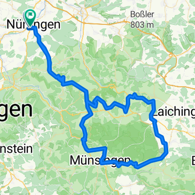
Cycling Route in Nürtingen, Baden-Württemberg, Germany

Nürtingen - Lenningen - Filsursprung - Gruibingen - Kirchheim

0
Open this route in the Bikemap app

Open this route in the Bikemap app

Open this route in Bikemap Web

Open this route in Bikemap Web

75 km
Distance
679 m
Ascent
676 m
Descent
-:-- h
Duration
-- km/h
Avg. Speed
--- m
Max. Elevation

About This Route

Start Nürtingen Bahnhof. Rechts der bahnlinie nach Oberboihingen durch das Donzdorfertal an den Bürgerseen, Hahnweide nach Dettingen/Teck. Weiter nach Owen, Oberlenninger, Alte lenninger Steige hinauf zum Schopflocher Moor. Von hier über das Bahnhöfle zum Filsursprung. Wiesensteig, Gruibingen, Weilheim Kirchheim, Wendlingen zurück nach Nürtingen.

This cycling route is ideal for: MTB

You will cycle on the following surfaces: Gravel

Customize this cycling route with the Bikemap route planner.

Make it yours!

Did you know? You can use this route as a template in our cycling route planner if you don't wish to start from scratch. Customize it based on your needs to plan your perfect cycling tour.

Open it in the app