

03_RR_2014_Einsiedeln - Arth
A cycling route starting in Einsiedeln, Canton of Schwyz, Switzerland.
Overview
About this route
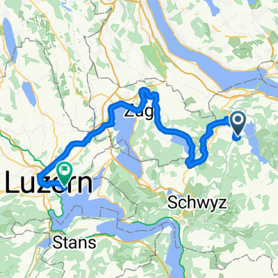
Einsiedeln - Arth
42.72km 1260hm- -:--
- Duration
- 42.7 km
- Distance
- 1,165 m
- Ascent
- 1,649 m
- Descent
- ---
- Avg. speed
- ---
- Max. altitude

Route highlights
Points of interest along the route
Point of interest after 0 km
00km Start 3. Etappe Einsiedeln, Klosterplatz Bus 551 / 552 / 553 / 556
Point of interest after 6.2 km
6.30km Einsiedeln, Kreisel hinter Bahnhof Zug S13 / S31
Point of interest after 11.2 km
10.90km Altmatt, Bahnhof Zug S31
Point of interest after 17.1 km
16.50km Rämslistrasse 101, 6315 Oberägeri nur Verpflegung
Point of interest after 20.5 km
19.80km Oberägeri, Pfrundhaus Bus 9 und 10
Point of interest after 25.2 km
24.50km Hinterwiedenstrasse; 6315 Oberägeri nur Verpflegung
Point of interest after 30 km
29.30km Unterägeri, Zimmel (Hotel Freihof) Bus 1 und 34
Point of interest after 34.1 km
33.80km Ochsenfeissi nur Verpflegung
Point of interest after 37.4 km
37.10km Rufibachstrasse nur Verpflegung
Point of interest after 42.7 km
42.66km Ziel 3. Etappe Arth, Am See Bus 21
Continue with Bikemap
Use, edit, or download this cycling route
You would like to ride 03_RR_2014_Einsiedeln - Arth or customize it for your own trip? Here is what you can do with this Bikemap route:
Free features
- Save this route as favorite or in collections
- Copy & plan your own version of this route
- Sync your route with Garmin or Wahoo
Premium features
Free trial for 3 days, or one-time payment. More about Bikemap Premium.
- Navigate this route on iOS & Android
- Export a GPX / KML file of this route
- Create your custom printout (try it for free)
- Download this route for offline navigation
Discover more Premium features.
Get Bikemap PremiumFrom our community
Other popular routes starting in Einsiedeln
 Einsiedeln - Sihl - Wollishofen
- Distance
- 44.7 km
- Ascent
- 156 m
- Descent
- 616 m
- Location
- Einsiedeln, Canton of Schwyz, Switzerland
 Hummel 1
- Distance
- 22.1 km
- Ascent
- 542 m
- Descent
- 541 m
- Location
- Einsiedeln, Canton of Schwyz, Switzerland
 Hoch Ybrig Runde
- Distance
- 46.7 km
- Ascent
- 1,046 m
- Descent
- 1,048 m
- Location
- Einsiedeln, Canton of Schwyz, Switzerland
 CH17_Rund um den Sihlsee
- Distance
- 22.7 km
- Ascent
- 107 m
- Descent
- 107 m
- Location
- Einsiedeln, Canton of Schwyz, Switzerland
 SoTo 2018/7: Einsiedeln - Luzern
- Distance
- 79 km
- Ascent
- 215 m
- Descent
- 676 m
- Location
- Einsiedeln, Canton of Schwyz, Switzerland
 Hundwilerä
- Distance
- 9 km
- Ascent
- 408 m
- Descent
- 402 m
- Location
- Einsiedeln, Canton of Schwyz, Switzerland
 Einsiedeln - Emmen
- Distance
- 55.4 km
- Ascent
- 670 m
- Descent
- 1,093 m
- Location
- Einsiedeln, Canton of Schwyz, Switzerland
 Etzel-Rapperswil-Schmerikon-Wangen-Siebne-Sattelegg-Einsiedeln
- Distance
- 66.6 km
- Ascent
- 1,190 m
- Descent
- 1,190 m
- Location
- Einsiedeln, Canton of Schwyz, Switzerland
Open it in the app