Premium Badge Download on the App Store Get it on Google Play Turn-by-turn Navigation Offline Maps Bike Type Optimized Routing Premium Maps Custom Bike Computer Export Routes Route Previews Fall Detection Premium Support

Cycling Route in Ille-sur-TĂȘt, Languedoc-Roussillon-Midi-PyrĂ©nĂ©es, France

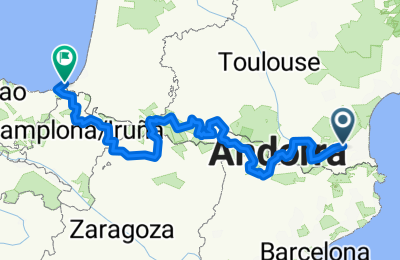
Traversata dei Pirenei (dal Mediterraneo all' Atlantico)

1
Open this route in the Bikemap app

Open this route in the Bikemap app

Open this route in Bikemap Web

Open this route in Bikemap Web

940 km
Distance
9261 m
Ascent
9374 m
Descent
-:-- h
Duration
-- km/h
Avg. Speed
--- m
Max. Elevation

About This Route

  1. Ille sur Tèt - Ax les Thermes              (km. 121 - disvlivello mt. 2.980)
  2. Ax les Thermes -Sort                                 (km. 136 - dislivello mt. 3.090)
  3. Sort - Mauleon/Barousse                 (km. 122 - dislivello mt. 2.040)    
  4. Mauleon/Barousse - Saint Lary Soulan (km. 74 - dislivello mt. 2.620)
  5. Saint Lary Soulan - Argelès/Gazost (km. 89 - dislivello mt. 2.320)
  6. Argelès/Gazost - Jaca                       (km. 132 - dislivello mt. 3.220)
  7. Jaca - Auritz/Burguete                       (km. 131 - dislivello mt. 1.830)
  8. Auritz/Burguete - Hondarribia                  (km. 139 - dislivello mt. 2.800)              n. 8 tappe per complessivi km. 940 e mt. 16.320 di dislivello

This cycling route is ideal for: Road bike

You will cycle on the following surfaces: Paved

Customize this cycling route with the Bikemap route planner.

Make it yours!

Did you know? You can use this route as a template in our cycling route planner if you don't wish to start from scratch. Customize it based on your needs to plan your perfect cycling tour.

Open it in the app