

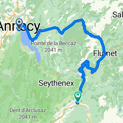
Annecy to Bormio
A cycling route starting in Annecy, Auvergne-Rhône-Alpes, France.
Overview
About this route
A mountainous route linking Annecy to Bormio
- -:--
- Duration
- 732.2 km
- Distance
- 9,503 m
- Ascent
- 8,752 m
- Descent
- ---
- Avg. speed
- ---
- Max. altitude

Route highlights
Points of interest along the route
Point of interest after 14.8 km
Le Semnoz. Recently in Tour de France. Great climb.
Point of interest after 41.1 km
Join Annecy . Albertville Bike path here
Point of interest after 76.6 km
Col de la Forclaz de Queige - small climb tht avoids albertville and some busier roads ... not the famous Annecy Col de la Forclaz
Point of interest after 84.2 km
Point of interest after 94.9 km
Col du Pré
Point of interest after 112 km
Cormet de Roselend
Point of interest after 161.2 km
Col du Petit St Bernard
Point of interest after 171.2 km
Passo St Carlo - Avoids the busier diect way down and adds a nice climb. You climb the far shorter easy side and descend a great road
Point of interest after 246.1 km
Col du Grand St Bernard. High and Beautiful. Italian side is far better, so climbing the good side
Point of interest after 431.4 km
Nufenenpass - Highest paved pass in Switzerland (Umbrailpass not fully paved)
Point of interest after 432.8 km
Furkapass
Point of interest after 474.9 km
Gotthard Pass
Point of interest after 494 km
Oberalpass . Nice lake here
Point of interest after 622.3 km
Albulapass . great climb
Point of interest after 708.2 km
Passo di Foscagno 2291 metres . Don't know it. Could also enter italy a little further south via Passo del Bernina, but I think this is quieter.
Point of interest after 730.3 km
Stelvio
Point of interest after 732.1 km
Passo di Gavia
Continue with Bikemap
Use, edit, or download this cycling route
You would like to ride Annecy to Bormio or customize it for your own trip? Here is what you can do with this Bikemap route:
Free features
- Save this route as favorite or in collections
- Copy & plan your own version of this route
- Split it into stages to create a multi-day tour
- Sync your route with Garmin or Wahoo
Premium features
Free trial for 3 days, or one-time payment. More about Bikemap Premium.
- Navigate this route on iOS & Android
- Export a GPX / KML file of this route
- Create your custom printout (try it for free)
- Download this route for offline navigation
Discover more Premium features.
Get Bikemap PremiumFrom our community
Other popular routes starting in Annecy
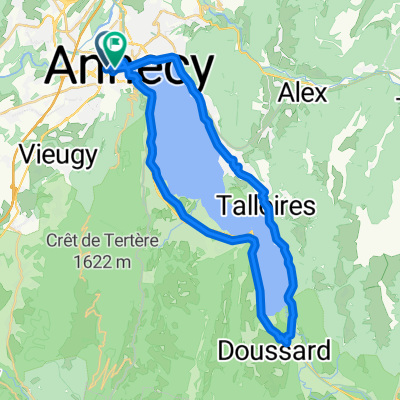
 Tour of Lake Annecy
- Distance
- 39.9 km
- Ascent
- 320 m
- Descent
- 329 m
- Location
- Annecy, Auvergne-Rhône-Alpes, France
 26-02 Rund um den Lac d'Annecy
- Distance
- 40.3 km
- Ascent
- 350 m
- Descent
- 346 m
- Location
- Annecy, Auvergne-Rhône-Alpes, France
 Annecy lake round
- Distance
- 37.5 km
- Ascent
- 343 m
- Descent
- 343 m
- Location
- Annecy, Auvergne-Rhône-Alpes, France
 02 Annecy-Moûtiers
- Distance
- 70.8 km
- Ascent
- 294 m
- Descent
- 268 m
- Location
- Annecy, Auvergne-Rhône-Alpes, France
 Rhone-Alpes: Etappe 1
- Distance
- 100.2 km
- Ascent
- 1,888 m
- Descent
- 1,997 m
- Location
- Annecy, Auvergne-Rhône-Alpes, France
 Annecy to Bormio
- Distance
- 732.2 km
- Ascent
- 9,503 m
- Descent
- 8,752 m
- Location
- Annecy, Auvergne-Rhône-Alpes, France
 Route in Annecy
- Distance
- 39.3 km
- Ascent
- 345 m
- Descent
- 347 m
- Location
- Annecy, Auvergne-Rhône-Alpes, France
 FORCLAZ MONTMIN VERSANT SUD 31MAI 2014
- Distance
- 54.5 km
- Ascent
- 757 m
- Descent
- 759 m
- Location
- Annecy, Auvergne-Rhône-Alpes, France
Open it in the app