Premium Badge Download on the App Store Get it on Google Play Turn-by-turn Navigation Offline Maps Bike Type Optimized Routing Premium Maps Custom Bike Computer Export Routes Route Previews Fall Detection Premium Support

Cycling Route in Buttenheim, Bavaria, Germany

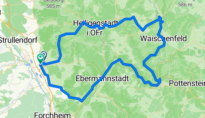
Fränkische Schweiz - Wiesenttal

0
Open this route in the Bikemap app

Open this route in the Bikemap app

Open this route in Bikemap Web

Open this route in Bikemap Web

89 km
Distance
590 m
Ascent
622 m
Descent
-:-- h
Duration
-- km/h
Avg. Speed
--- m
Max. Elevation

About This Route

Pkw Anfahrt nach Breitenlesau (Parkplatz Bürgerhaus). zunächst nach Plankenfels. dann stets entlag der Wiesent über Waischenfeld, Behringersmühle  bis Ebermannstadt od. Forchheim.

Rückfahrt: 1 Pkw zuvor in Ebermannstadt abstellen (Parkplatz Landratsamt) oder Rückfahrt mit Zug VGN-Nünberg: Ebermannstdt: 14.40, 15.40, 16.40, 17.00 Uhr 1 x umsteigen 53 Mi. Fahrzeit; oder Forcheim 1/2 stündl., 7 Min.Fahrzeit


You will cycle on the following surfaces: Paved

Customize this cycling route with the Bikemap route planner.

Make it yours!

Did you know? You can use this route as a template in our cycling route planner if you don't wish to start from scratch. Customize it based on your needs to plan your perfect cycling tour.

Open it in the app