
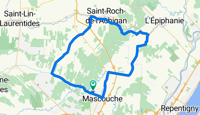
45 km école de la Source
A cycling route starting in Mascouche, Quebec, Canada.
Overview
About this route
Stationnement à l'école de la Source
<span style="color: rgb(38, 55, 63); font-family: Verdana, Helvetica, sans-serif; font-size: 11px; text-align: justify;">1275, avenue Châteaubriant</span><br style="color: rgb(38, 55, 63); font-family: Verdana, Helvetica, sans-serif; font-size: 11px; text-align: justify;" /> <span style="color: rgb(38, 55, 63); font-family: Verdana, Helvetica, sans-serif; font-size: 11px; text-align: justify;">Mascouche, Québec J7K 2B3</span>- -:--
- Duration
- 45.3 km
- Distance
- 70 m
- Ascent
- 71 m
- Descent
- ---
- Avg. speed
- ---
- Avg. speed

Route quality
Waytypes & surfaces along the route
Waytypes
Road
38.1 km
(84 %)
Busy road
6.7 km
(15 %)
Surfaces
Paved
42.9 km
(95 %)
Asphalt
25.4 km
(56 %)
Paved (undefined)
17.5 km
(39 %)
Undefined
2.3 km
(5 %)
Continue with Bikemap
Use, edit, or download this cycling route
You would like to ride 45 km école de la Source or customize it for your own trip? Here is what you can do with this Bikemap route:
Free features
- Save this route as favorite or in collections
- Copy & plan your own version of this route
- Sync your route with Garmin or Wahoo
Premium features
Free trial for 3 days, or one-time payment. More about Bikemap Premium.
- Navigate this route on iOS & Android
- Export a GPX / KML file of this route
- Create your custom printout (try it for free)
- Download this route for offline navigation
Discover more Premium features.
Get Bikemap PremiumFrom our community
Other popular routes starting in Mascouche
 985 Rue Lapointe, Mascouche to 515 Ch du Moulin, Ste-Adèle
- Distance
- 84.6 km
- Ascent
- 579 m
- Descent
- 274 m
- Location
- Mascouche, Quebec, Canada
 Des-Rives 50 km
- Distance
- 50.1 km
- Ascent
- 35 m
- Descent
- 33 m
- Location
- Mascouche, Quebec, Canada
 karino
- Distance
- 52.5 km
- Ascent
- 26 m
- Descent
- 27 m
- Location
- Mascouche, Quebec, Canada
 De 735 Rue Mercier, Mascouche à 726 Rue Mercier, Mascouche
- Distance
- 30.4 km
- Ascent
- 110 m
- Descent
- 109 m
- Location
- Mascouche, Quebec, Canada
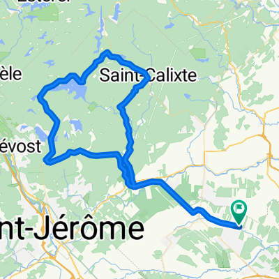
 Mascouche - l'Epiphanie - St-Roch
- Distance
- 55.2 km
- Ascent
- 58 m
- Descent
- 58 m
- Location
- Mascouche, Quebec, Canada
 Le Prelude-Epiphanie-Retour
- Distance
- 41.7 km
- Ascent
- 38 m
- Descent
- 40 m
- Location
- Mascouche, Quebec, Canada
 Les collines du lac Achigan
- Distance
- 92.7 km
- Ascent
- 489 m
- Descent
- 487 m
- Location
- Mascouche, Quebec, Canada
 Des-Rives 58 km
- Distance
- 58.1 km
- Ascent
- 38 m
- Descent
- 35 m
- Location
- Mascouche, Quebec, Canada
Open it in the app