

NORWAY-2015 (B)
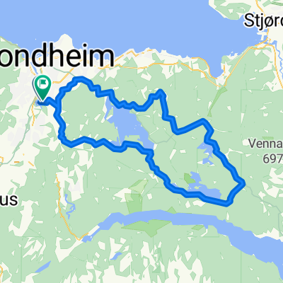
A cycling route starting in Trondheim, Sør-Trøndelag Fylke, Norway.
Overview
About this route
<span style="font-size: 12px;">(01) flight SPb - Oslo, night train to Trondheim</span>
<span style="font-size: 12px;">(02, 03) Trondheim - Kristiansund (200 km)</span> (04,05) Kristiansund - Molde -<span style="font-size: 12px;"> Endalsnes (200 km)</span> (06) Endalsnes - Valldalen - Geiranger <span style="font-size: 12px;">(60 km)</span> (07) Geiranger (08) Valldalen - Hellesylt - Stryn (60 km) (09) Stryn - Kjenndalstova - Lorn (120 km) (10) Lom - Sogndal (100 km) (11) Nigardsbreen <span style="font-size: 12px;">(12) Sogndal - Hellen - Voss (120 km)</span> (13) Voss - Granvin (100 km) (14) Granvin<span style="font-size: 12.222222328186px;"> - Kvandall - </span><span style="font-size: 12.222222328186px;"> </span><span style="font-size: 12.222222328186px;">Odda </span><span style="font-size: 12.222222328186px;">(100 km)</span> <span style="font-size: 12.222222328186px;">(15) Odda</span> (16) Odda - Lofthus (30 km) (17) Lofthus - Veringfossen (100 km) (18) Veringfossen - Haugastol - Flam (100 km) (19) Flam - Eksingedalen (120 km) (20) Eksingedalen - Dale (30 km), train to Oslo (21) flight Oslo - Spb- -:--
- Duration
- 1,440.1 km
- Distance
- 6,413 m
- Ascent
- 6,371 m
- Descent
- ---
- Avg. speed
- ---
- Max. altitude

Route highlights
Points of interest along the route
Point of interest after 502 km
обзорная площадка Gudbrandsjuvet
Point of interest after 543 km
средневековая ферма с отличным в видом на фьорд
Point of interest after 639.9 km
Отсюда видно ледник
Point of interest after 653.4 km
несколько обзорных точек (в т.ч. известный "язык")
Point of interest after 656.3 km
водопад Storsæterfossen
Point of interest after 861.5 km
ледник Nigardsbreen
Point of interest after 984.8 km
Водопад Tvindlefossen
Point of interest after 1,066.8 km
тропа к леднику
Point of interest after 1,068.5 km
Låtefossen
Point of interest after 1,313.1 km
Magical White Caves (посещение ровно в 12.00, 125 крон\чел)
Continue with Bikemap
Use, edit, or download this cycling route
You would like to ride NORWAY-2015 (B) or customize it for your own trip? Here is what you can do with this Bikemap route:
Free features
- Save this route as favorite or in collections
- Copy & plan your own version of this route
- Split it into stages to create a multi-day tour
- Sync your route with Garmin or Wahoo
Premium features
Free trial for 3 days, or one-time payment. More about Bikemap Premium.
- Navigate this route on iOS & Android
- Export a GPX / KML file of this route
- Create your custom printout (try it for free)
- Download this route for offline navigation
Discover more Premium features.
Get Bikemap PremiumFrom our community
Other popular routes starting in Trondheim
 Møllenberg, Lauset, Klett, Heimdal, Klæbu, Bratsberg og Møllenberg
- Distance
- 88.1 km
- Ascent
- 804 m
- Descent
- 799 m
- Location
- Trondheim, Sør-Trøndelag Fylke, Norway
 Trondheim-Kristiansund
- Distance
- 214.3 km
- Ascent
- 1,177 m
- Descent
- 1,288 m
- Location
- Trondheim, Sør-Trøndelag Fylke, Norway
 +100k
+100k- Distance
- 119.9 km
- Ascent
- 634 m
- Descent
- 634 m
- Location
- Trondheim, Sør-Trøndelag Fylke, Norway
 Trondheim - Bergen via åndalsnes
- Distance
- 994.1 km
- Ascent
- 2,823 m
- Descent
- 2,825 m
- Location
- Trondheim, Sør-Trøndelag Fylke, Norway
 Jonsvatnet, Foldsjøen, Drakstsjøen
- Distance
- 75.4 km
- Ascent
- 0 m
- Descent
- 0 m
- Location
- Trondheim, Sør-Trøndelag Fylke, Norway
 Ranheim-Lade-NTNU
- Distance
- 21.5 km
- Ascent
- 259 m
- Descent
- 361 m
- Location
- Trondheim, Sør-Trøndelag Fylke, Norway
 Fjellseterveien 20, Trondheim do Midtbyen, Trondheim
- Distance
- 10.2 km
- Ascent
- 545 m
- Descent
- 271 m
- Location
- Trondheim, Sør-Trøndelag Fylke, Norway
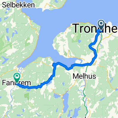 001: Trondheim – Fannrem (PLANNING) - 002: Fannrem – Voll (PLANNING) - 003: Voll – Oppdal (PLANNING) - 004: Oppdal – Hjerkinn (PLANNING) - 005: Hjerkinn – Do...
- Distance
- 53.8 km
- Ascent
- 851 m
- Descent
- 835 m
- Location
- Trondheim, Sør-Trøndelag Fylke, Norway
Open it in the app