
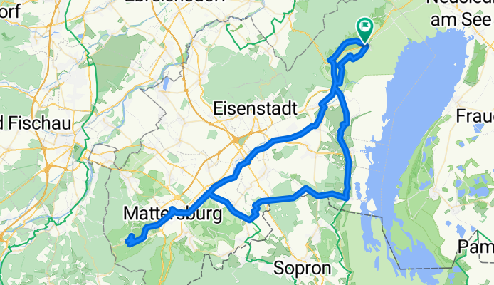
Von Purbach nach Forchtenstein
A cycling route starting in Donnerskirchen, Burgenland, Austria.
Overview
About this route
New paths in Burgenland.
- -:--
- Duration
- 102.6 km
- Distance
- 584 m
- Ascent
- 584 m
- Descent
- ---
- Avg. speed
- ---
- Max. altitude
Route quality
Waytypes & surfaces along the route
Waytypes
Quiet road
38 km
(37 %)
Track
26.7 km
(26 %)
Surfaces
Paved
83.1 km
(81 %)
Unpaved
1 km
(1 %)
Asphalt
81 km
(79 %)
Paved (undefined)
2.1 km
(2 %)
Continue with Bikemap
Use, edit, or download this cycling route
You would like to ride Von Purbach nach Forchtenstein or customize it for your own trip? Here is what you can do with this Bikemap route:
Free features
- Save this route as favorite or in collections
- Copy & plan your own version of this route
- Split it into stages to create a multi-day tour
- Sync your route with Garmin or Wahoo
Premium features
Free trial for 3 days, or one-time payment. More about Bikemap Premium.
- Navigate this route on iOS & Android
- Export a GPX / KML file of this route
- Create your custom printout (try it for free)
- Download this route for offline navigation
Discover more Premium features.
Get Bikemap PremiumFrom our community
Other popular routes starting in Donnerskirchen
 Kirschblütenradweg Donnerskirchen nach Jois und zurück
- Distance
- 42.6 km
- Ascent
- 276 m
- Descent
- 321 m
- Location
- Donnerskirchen, Burgenland, Austria
 Wiener Straße - Budapester Straße
- Distance
- 92.5 km
- Ascent
- 669 m
- Descent
- 767 m
- Location
- Donnerskirchen, Burgenland, Austria
 Von Purbach nach Forchtenstein
- Distance
- 102.6 km
- Ascent
- 584 m
- Descent
- 584 m
- Location
- Donnerskirchen, Burgenland, Austria
 maco 28.7.18
- Distance
- 61.5 km
- Ascent
- 1,342 m
- Descent
- 1,335 m
- Location
- Donnerskirchen, Burgenland, Austria
 Donnerskirchen - Jois
- Distance
- 38 km
- Ascent
- 247 m
- Descent
- 258 m
- Location
- Donnerskirchen, Burgenland, Austria
 From Purbach am Neusiedler See to Bratislava
- Distance
- 56.5 km
- Ascent
- 147 m
- Descent
- 107 m
- Location
- Donnerskirchen, Burgenland, Austria
 Am Leithaberg
- Distance
- 35.9 km
- Ascent
- 573 m
- Descent
- 573 m
- Location
- Donnerskirchen, Burgenland, Austria
 Bodenzeile - Campingplatz
- Distance
- 1.1 km
- Ascent
- 0 m
- Descent
- 7 m
- Location
- Donnerskirchen, Burgenland, Austria
Open it in the app