- 30.7 km
- 362 m
- 362 m
- Niederrad, Hesse, Germany
Ffm Rundfahrt am Main und Nidda
A cycling route starting in Niederrad, Hesse, Germany.
Overview
About this route
Frankfurt circuit along the Main and Nidda rivers.
The route starts at the Main (Gutleutstraße 391), follows the Main towards Frankfurt Höchst, passing Griesheim to Höchst Old Town, then continues along the Nidda through Rödelheim to Niddapark, from there to Grüneburgpark on cycle paths to the city center, and then back towards the Main and along the Main to the starting point.
The majority of the route goes through green areas of the city of Frankfurt, and only a small section from Grüneburgpark to the Main runs on cycle paths or through pedestrian zones in the city center.
There are plenty of places on the tour to stop for refreshment.
It is flat and passes many sights.
- -:--
- Duration
- 30.8 km
- Distance
- 91 m
- Ascent
- 91 m
- Descent
- ---
- Avg. speed
- ---
- Max. altitude
created this 10 years ago
Route quality
Waytypes & surfaces along the route
Waytypes
Path
14.5 km
47 %
Pedestrian area
5.9 km
19 %
Surfaces
Paved
19.4 km
(63 %)
Unpaved
4.9 km
(16 %)
Asphalt
17.9 km
58 %
Gravel
4.3 km
14 %
Route highlights
Points of interest along the route

Photo after 0 km
Startpunk: Orange Beach Ffm Gutleutstrasse

Photo after 6.6 km
Hoechster Stadtpark: Brücke über die Nidda.

Photo after 6.9 km
Hoechster Mainpanorama

Photo after 6.9 km
Bolongaropalast in Frankfurt Höchst

Photo after 7.1 km
Altstadt Ffm Höchst

Photo after 7.2 km
Höchster Schloss

Photo after 7.3 km
Markt- in FFm Hoechst

Photo after 11.1 km
Anglerheim Nied

Photo after 14.5 km
Parkterrasse im Rödelheimer Vereinsring

Photo after 19.1 km
Ginnheimer Wirtshaus

Photo after 19.6 km
Restaurant Blau-Gelb (Griechisches Restaurant)

Photo after 22.4 km
Ffm Grüneburgpark

Photo after 24.7 km
Ffm Alte Oper

Photo after 25.4 km
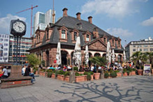
Ffm Hauptwache

Photo after 25.8 km
Ffm Paulskirche

Photo after 25.8 km
Ffm Roemer

Photo after 25.9 km
Ffm Römer Ostzeile

Photo after 25.9 km
Ffm Eisener Steg

Photo after 26.7 km
Ffm Mainnizza

Photo after 28.6 km
Chigago Meatpackers Riverside (Burger Restaurant)

Photo after 28.6 km
Druckwasserwerk (Restaurant)

Photo after 28.6 km
Druckwasserwerk (Restaurant)

Photo after 29.1 km
Sommerhoffpark
Continue with Bikemap
Use, edit, or download this cycling route
You would like to ride Ffm Rundfahrt am Main und Nidda or customize it for your own trip? Here is what you can do with this Bikemap route:
Free features
- Save this route as favorite or in collections
- Copy & plan your own version of this route
- Sync your route with Garmin or Wahoo
Premium features
Free trial for 3 days, or one-time payment. More about Bikemap Premium.
- Navigate this route on iOS & Android
- Export a GPX / KML file of this route
- Create your custom printout (try it for free)
- Download this route for offline navigation
Discover more Premium features.
Get Bikemap PremiumFrom our community
Other popular routes starting in Niederrad
- Lyoner Straße, Frankfurt am Main nach Lyoner Straße, Frankfurt am Main
- Lyoner Straße, Frankfurt am Main nach Töngesgasse, Frankfurt am Main
- 6.8 km
- 119 m
- 116 m
- Niederrad, Hesse, Germany
- Lyoner Straße, Frankfurt am Main nach Schmiedegasse, Offenbach am Main
- 18.9 km
- 186 m
- 183 m
- Niederrad, Hesse, Germany
- Lyoner Straße, Frankfurt am Main nach Lyoner Straße, Frankfurt am Main
- 26.4 km
- 303 m
- 324 m
- Niederrad, Hesse, Germany
- Lyoner Straße, Frankfurt am Main nach B43, Raunheim
- 19.5 km
- 131 m
- 163 m
- Niederrad, Hesse, Germany
- Lyoner Straße, Frankfurt am Main nach Lyoner Straße, Frankfurt am Main
- 15.5 km
- 268 m
- 304 m
- Niederrad, Hesse, Germany
- Lyoner Straße, Frankfurt am Main nach Emmerich-Josef-Straße, Frankfurt am Main
- 12.3 km
- 90 m
- 89 m
- Niederrad, Hesse, Germany
- Lyoner Straße, Frankfurt am Main nach Mainstraße, Mühlheim am Main
- 20.9 km
- 116 m
- 116 m
- Niederrad, Hesse, Germany
Open it in the app