Premium Badge Download on the App Store Get it on Google Play Turn-by-turn Navigation Offline Maps Bike Type Optimized Routing Premium Maps Custom Bike Computer Export Routes Route Previews Fall Detection Premium Support

Cycling Route in Steyr, Upper Austria, Austria

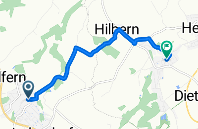
Wolfern - Dietach (Ortszentren, Umgehung von Hauptverkehrsstraßen)

1
Open this route in the Bikemap app

Open this route in the Bikemap app

Open this route in Bikemap Web

Open this route in Bikemap Web

4 km
Distance
33 m
Ascent
80 m
Descent
-:-- h
Duration
-- km/h
Avg. Speed
--- m
Max. Elevation

About This Route

Vom Wolferner Zentrum aus geht es zunächst nach Osten, die Kirchenstraße hinunter, dann nach NO auf der Englmayrstraße am Schwimmbad vorbei, über den Simsenbergbach, an einem Vierkanthof vorbei und dann weiter über ein Feld. Nachfolgend kommt eine kleine Kreuzung vor zwei Höfen, wo man sich rechts halten muss und einem geschotterten Weg durch ein Waldstück folgt., bevor man in Hilbern einen ausgebauten Bauernhof durchquert. Danach geht's rechts auf die Thannstraße, beim folgenden Kreisverkehr links auf die Heubergstraße. Nach wenigen Metern muss man nun nach rechts auf den Pfarrberg abbiegen, welcher schließlich steil bergab nach Dietach führt. Im Ort noch einmal rechts abbiegen, und das Zentrum mit Gemeindeamt ist erreicht!

Dauer: 10-15 Minuten

This cycling route is ideal for: MTB City bike

You will cycle on the following surfaces: Paved Gravel

Customize this cycling route with the Bikemap route planner.

Make it yours!

Did you know? You can use this route as a template in our cycling route planner if you don't wish to start from scratch. Customize it based on your needs to plan your perfect cycling tour.

Open it in the app