

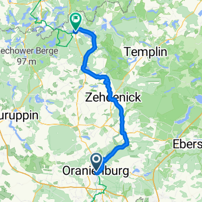
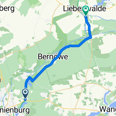
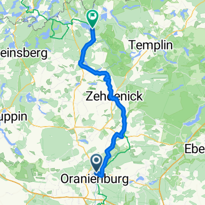
2015-09-15 Oranienburg-Liebenwalde
A cycling route starting in Oranienburg, Brandenburg, Germany.
Overview
About this route
rundkurs Oranienburg - Lie
benwalde - Oranienburg(cloned from route 3272566)
- -:--
- Duration
- 42.9 km
- Distance
- 89 m
- Ascent
- 88 m
- Descent
- ---
- Avg. speed
- ---
- Max. altitude
Route quality
Waytypes & surfaces along the route
Waytypes
Path
22.7 km
(53 %)
Track
8.1 km
(19 %)
Surfaces
Paved
38.6 km
(90 %)
Unpaved
2.6 km
(6 %)
Asphalt
38.6 km
(90 %)
Gravel
1.3 km
(3 %)
Continue with Bikemap
Use, edit, or download this cycling route
You would like to ride 2015-09-15 Oranienburg-Liebenwalde or customize it for your own trip? Here is what you can do with this Bikemap route:
Free features
- Save this route as favorite or in collections
- Copy & plan your own version of this route
- Sync your route with Garmin or Wahoo
Premium features
Free trial for 3 days, or one-time payment. More about Bikemap Premium.
- Navigate this route on iOS & Android
- Export a GPX / KML file of this route
- Create your custom printout (try it for free)
- Download this route for offline navigation
Discover more Premium features.
Get Bikemap PremiumFrom our community
Other popular routes starting in Oranienburg
 Wald Finow Wald
- Distance
- 61 km
- Ascent
- 131 m
- Descent
- 99 m
- Location
- Oranienburg, Brandenburg, Germany
 15.09.13 Oranienburg <> Liebenberg
- Distance
- 38.2 km
- Ascent
- 113 m
- Descent
- 112 m
- Location
- Oranienburg, Brandenburg, Germany
 Berlin-Kopenhagen: Oranienburg bis Fürstenberg
- Distance
- 77.7 km
- Ascent
- 297 m
- Descent
- 277 m
- Location
- Oranienburg, Brandenburg, Germany
 Usedom
- Distance
- 210.3 km
- Ascent
- 256 m
- Descent
- 288 m
- Location
- Oranienburg, Brandenburg, Germany
 Straße der Einheit, Oranienburg nach Brandenburger Straße, Fürstenberg/Havel
- Distance
- 77.1 km
- Ascent
- 275 m
- Descent
- 249 m
- Location
- Oranienburg, Brandenburg, Germany
 Carl-Gustav-Hempel-Straße, Oranienburg nach Am Finowkanal, Liebenwalde
- Distance
- 17.2 km
- Ascent
- 42 m
- Descent
- 40 m
- Location
- Oranienburg, Brandenburg, Germany
 Bernauer Straße, Oranienburg nach Hanns-Krause-Weg, Stechlin
- Distance
- 58.6 km
- Ascent
- 169 m
- Descent
- 135 m
- Location
- Oranienburg, Brandenburg, Germany
 Himmelpfort Camping
- Distance
- 67 km
- Ascent
- 347 m
- Descent
- 340 m
- Location
- Oranienburg, Brandenburg, Germany
Open it in the app