Premium Badge Download on the App Store Get it on Google Play Turn-by-turn Navigation Offline Maps Bike Type Optimized Routing Premium Maps Custom Bike Computer Export Routes Route Previews Fall Detection Premium Support

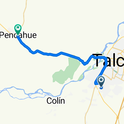
Cycling Route in Talca, Maule, Chile

ETAPA 2 - SUB ETAPA 1 VUELTA CICLISTA MAULE CENTRO 2016

0
Open this route in the Bikemap app

Open this route in the Bikemap app

Open this route in Bikemap Web

Open this route in Bikemap Web

108 km
Distance
527 m
Ascent
347 m
Descent
-:-- h
Duration
-- km/h
Avg. Speed
--- m
Max. Elevation

About This Route

ETAPA: TALCA – SAN CLEMENTE - CRUCE CORRALONES – PELARCO – TALCA RUTAS: CH-115, K-25, K-45, RUTA 5, K-60 HORA DE CITACIÓN: 08:30 HORAS

HORA DE LARGADA: 09:00 HORAS

LUGAR DE PARTIDA: PLAZA DE ARMAS DE TALCA

LUGAR DE LLEGADA: CUMBRE CERRO LA VIRGEN

TOTAL KILÓMETROS: 106 KM APROXIMADO.

HORA APROXIMADA DE LLEGADA: 12:00 HORAS.

RECORRIDO: PARTIDA PLAZA DE ARMAS DE TALCA, 1 NORTE FRONTIS I. MUNICIPALIDAD DE TALCA – 1 ORIENTE – 1 SUR – 1 PONIENTE – DIAGONAL ISIDORO DEL SOLAR – ALAMEDA 4 NORTE – 11 ORIENTE – AVDA. 2 NORTE HASTA 30 ORIENTE – INGRESO A RUTA CH-115 – SAN CLEMENTE – CRUCE CORRALONES – RUTA K-25 – CRUCE RUTA K-45 HACIA PELARCO, – PLAZA DE ARMAS DE PELARCO – RUTA K-45 – CRUCE PANGUILEMO – RUTA 5 HACIA EL SUR – CRUCE LIRCAY HACIA TALCA – CIRCUNVALACIÓN NORTE – ALAMEDA 4 NORTE HACIA PENCAHUE – RUTA K-60 – ASCENSO CERRO LA VIRGEN – META FRENTE A MIRADOR.

You will cycle on the following surfaces: Paved

Customize this cycling route with the Bikemap route planner.

Make it yours!

Did you know? You can use this route as a template in our cycling route planner if you don't wish to start from scratch. Customize it based on your needs to plan your perfect cycling tour.

Open it in the app