Premium Badge Download on the App Store Get it on Google Play Turn-by-turn Navigation Offline Maps Bike Type Optimized Routing Premium Maps Custom Bike Computer Export Routes Route Previews Fall Detection Premium Support

Cycling Route in Barjac, Languedoc-Roussillon-Midi-Pyrénées, France

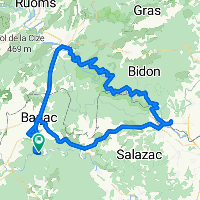
Le Pont d'Arc - Dent de Rez - St. Remeze - Le Pont d'Arc

0
Open this route in the Bikemap app

Open this route in the Bikemap app

Open this route in Bikemap Web

Open this route in Bikemap Web

35 km
Distance
734 m
Ascent
741 m
Descent
-:-- h
Duration
-- km/h
Avg. Speed
--- m
Max. Elevation

About This Route

Diese Tour ist erst geplant und soll im Mai gefahren werden.

Der Dent de Rez ist die höchste Erhebung der Umgebung und man soll einen tollen Blick von dort oben haben selbstverständlich die Cevennen im Westen und der Mont Ventoux im Osten).

This cycling route is ideal for: MTB

You will cycle on the following surfaces: Paved Unpaved

Customize this cycling route with the Bikemap route planner.

Make it yours!

Did you know? You can use this route as a template in our cycling route planner if you don't wish to start from scratch. Customize it based on your needs to plan your perfect cycling tour.

Open it in the app