

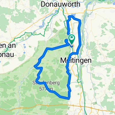
Nordendorf - Dollnstein
A cycling route starting in Nordendorf, Bavaria, Germany.
Overview
About this route
- -:--
- Duration
- 57.2 km
- Distance
- 192 m
- Ascent
- 224 m
- Descent
- ---
- Avg. speed
- ---
- Avg. speed

Route quality
Waytypes & surfaces along the route
Waytypes
Quiet road
27.6 km
(48 %)
Path
10.8 km
(19 %)
Surfaces
Paved
44 km
(77 %)
Unpaved
9.7 km
(17 %)
Asphalt
43.8 km
(77 %)
Gravel
7.7 km
(14 %)
Route highlights
Points of interest along the route
Photo after 39.6 km
2. Zeltplatz
Continue with Bikemap
Use, edit, or download this cycling route
You would like to ride Nordendorf - Dollnstein or customize it for your own trip? Here is what you can do with this Bikemap route:
Free features
- Save this route as favorite or in collections
- Copy & plan your own version of this route
- Sync your route with Garmin or Wahoo
Premium features
Free trial for 3 days, or one-time payment. More about Bikemap Premium.
- Navigate this route on iOS & Android
- Export a GPX / KML file of this route
- Create your custom printout (try it for free)
- Download this route for offline navigation
Discover more Premium features.
Get Bikemap PremiumFrom our community
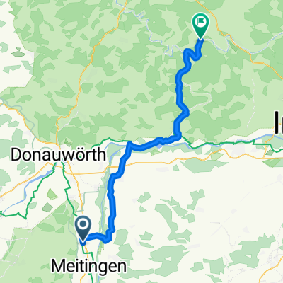
Other popular routes starting in Nordendorf
 Sand Thierhaupten
- Distance
- 34.1 km
- Ascent
- 53 m
- Descent
- 59 m
- Location
- Nordendorf, Bavaria, Germany
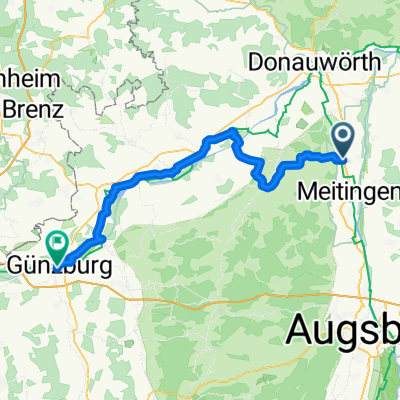 Nordendorf_Günzburg
- Distance
- 69.3 km
- Ascent
- 159 m
- Descent
- 131 m
- Location
- Nordendorf, Bavaria, Germany
 Lauterbach Butt
- Distance
- 25.8 km
- Ascent
- 101 m
- Descent
- 102 m
- Location
- Nordendorf, Bavaria, Germany
 Nordendorf richtung Augsburg
- Distance
- 90.1 km
- Ascent
- 305 m
- Descent
- 308 m
- Location
- Nordendorf, Bavaria, Germany
 Nordendorf - Dollnstein
- Distance
- 57.2 km
- Ascent
- 192 m
- Descent
- 224 m
- Location
- Nordendorf, Bavaria, Germany
 BUCH 2012 T4.03 Nordendorf-Erlingen
- Distance
- 9.2 km
- Ascent
- 16 m
- Descent
- 0 m
- Location
- Nordendorf, Bavaria, Germany
 2020_T1_Schwaben_Günzburg
- Distance
- 74.8 km
- Ascent
- 172 m
- Descent
- 127 m
- Location
- Nordendorf, Bavaria, Germany
 Nordendorf-Druisheim-Allmannshofen-Blankenburg(Wasserturm)-Blankenburg-Kühlenthal-Fertingen-Ortlfin
- Distance
- 24.2 km
- Ascent
- 178 m
- Descent
- 180 m
- Location
- Nordendorf, Bavaria, Germany
Open it in the app