Premium Badge Download on the App Store Get it on Google Play Turn-by-turn Navigation Offline Maps Bike Type Optimized Routing Premium Maps Custom Bike Computer Export Routes Route Previews Fall Detection Premium Support

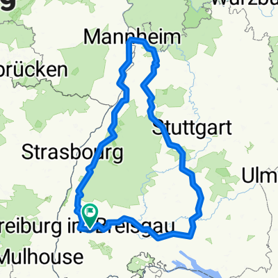
Cycling Route in Stegen, Baden-Württemberg, Germany

MMXTR Hornisgrindetour 2007

0
Open this route in the Bikemap app

Open this route in the Bikemap app

Open this route in Bikemap Web

Open this route in Bikemap Web

201 km
Distance
3209 m
Ascent
3431 m
Descent
-:-- h
Duration
-- km/h
Avg. Speed
1125 m
Max. Elevation

About This Route

This cycling route is ideal for: Road bike

You will cycle on the following surfaces: Paved

Highlights Along The Route

Point of Interest

Hinter der Kirche öffentliches WC

Point of Interest

Brunnen an der Passhöhe

Point of Interest

Marktbrunnen mit Trinkwasser

Customize this cycling route with the Bikemap route planner.

Make it yours!

Did you know? You can use this route as a template in our cycling route planner if you don't wish to start from scratch. Customize it based on your needs to plan your perfect cycling tour.

Open it in the app