

Merkendorf ... T e s t !!!
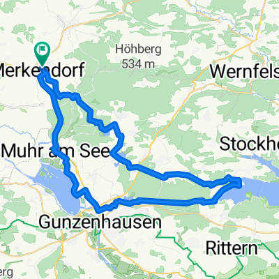
A cycling route starting in Merkendorf, Bavaria, Germany.
Overview
About this route
Rast in Dietenhofen
teilweise noch nicht gefahren
- -:--
- Duration
- 108.7 km
- Distance
- 695 m
- Ascent
- 695 m
- Descent
- ---
- Avg. speed
- ---
- Avg. speed
Route quality
Waytypes & surfaces along the route
Waytypes
Quiet road
77.1 km
(71 %)
Track
17.3 km
(16 %)
Surfaces
Paved
51.7 km
(48 %)
Unpaved
0.6 km
(<1 %)
Asphalt
42.5 km
(39 %)
Paved (undefined)
7.2 km
(7 %)
Continue with Bikemap
Use, edit, or download this cycling route
You would like to ride Merkendorf ... T e s t !!! or customize it for your own trip? Here is what you can do with this Bikemap route:
Free features
- Save this route as favorite or in collections
- Copy & plan your own version of this route
- Sync your route with Garmin or Wahoo
Premium features
Free trial for 3 days, or one-time payment. More about Bikemap Premium.
- Navigate this route on iOS & Android
- Export a GPX / KML file of this route
- Create your custom printout (try it for free)
- Download this route for offline navigation
Discover more Premium features.
Get Bikemap PremiumFrom our community
Other popular routes starting in Merkendorf
 Merkendorf Windsbach Untereschenbach u. zurück
- Distance
- 43 km
- Ascent
- 388 m
- Descent
- 389 m
- Location
- Merkendorf, Bavaria, Germany
 Tour 4 Brombachsee
- Distance
- 41.8 km
- Ascent
- 181 m
- Descent
- 181 m
- Location
- Merkendorf, Bavaria, Germany
 Merkendorf - Teuchtlingen
- Distance
- 41 km
- Ascent
- 63 m
- Descent
- 88 m
- Location
- Merkendorf, Bavaria, Germany
 Simson Tour - Merkendorf -> Hammermühle
- Distance
- 94.9 km
- Ascent
- 930 m
- Descent
- 970 m
- Location
- Merkendorf, Bavaria, Germany
 Marktplatz 10, Merkendorf nach Marktplatz 10, Merkendorf
- Distance
- 38.3 km
- Ascent
- 368 m
- Descent
- 368 m
- Location
- Merkendorf, Bavaria, Germany
 Altmühlsee brombachsee
- Distance
- 64.4 km
- Ascent
- 278 m
- Descent
- 277 m
- Location
- Merkendorf, Bavaria, Germany
 Merkendorf3
- Distance
- 47.9 km
- Ascent
- 213 m
- Descent
- 214 m
- Location
- Merkendorf, Bavaria, Germany
 Merkendorf ... T e s t !!!
- Distance
- 108.7 km
- Ascent
- 695 m
- Descent
- 695 m
- Location
- Merkendorf, Bavaria, Germany
Open it in the app