Premium Badge Download on the App Store Get it on Google Play Turn-by-turn Navigation Offline Maps Bike Type Optimized Routing Premium Maps Custom Bike Computer Export Routes Route Previews Fall Detection Premium Support

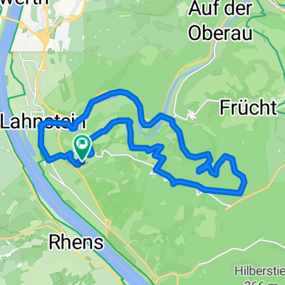
Cycling Route in Lahnstein, Rhineland-Palatinate, Germany

Rhein-Hunsrück-Mosel-Tour

1
Open this route in the Bikemap app

Open this route in the Bikemap app

Open this route in Bikemap Web

Open this route in Bikemap Web

91 km
Distance
937 m
Ascent
927 m
Descent
-:-- h
Duration
-- km/h
Avg. Speed
--- m
Max. Elevation

About This Route

Streckenführung:<br /><br />

Horchheim, KO- Oberwerth, Boppard, Rheinbay, Karbach, <br /> Emmelshausen, Gondershausen, Brodenbach, Herschwiesen,<br /> Buchholz, Boppard, Ko-Oberwerth, Horchheim.<br /><br />

Anspruchsvolle, Landschaftliche <span> </span>schöne Strecke.<br /> Von Koblenz bis Boppard ist fast durchgehend ein Radweg.<br />

Es gibt drei knackigen Steigungen.<br /> 1. vor <span style="mso-spacerun: yes;"> </span>Weiler, 2. vor Karbach u. 3. bei Brodenbach.<br /><br /> Tiefster Punkt 68 ÜNN bei Koblenz Oberwerth und höchster ca. 500 ÜNN hinter Karbach.

<br />Viel Spaß

This cycling route is ideal for: Road bike

You will cycle on the following surfaces: Paved

Customize this cycling route with the Bikemap route planner.

Make it yours!

Did you know? You can use this route as a template in our cycling route planner if you don't wish to start from scratch. Customize it based on your needs to plan your perfect cycling tour.

Open it in the app