

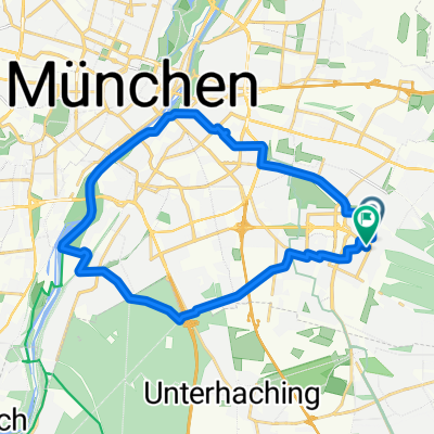
Monaco-Castelli Baviera-Danubio 500km
A cycling route starting in Neubiberg, Bavaria, Germany.
Overview
About this route
- 27 h 50 min
- Duration
- 466.6 km
- Distance
- 2,522 m
- Ascent
- 2,714 m
- Descent
- 16.8 km/h
- Avg. speed
- ---
- Max. altitude

Route photos


Route quality
Waytypes & surfaces along the route
Waytypes
Quiet road
149.3 km
(32 %)
Path
144.6 km
(31 %)
Surfaces
Paved
387.3 km
(83 %)
Unpaved
18.7 km
(4 %)
Asphalt
373.3 km
(80 %)
Paved (undefined)
14 km
(3 %)
Continue with Bikemap
Use, edit, or download this cycling route
You would like to ride Monaco-Castelli Baviera-Danubio 500km or customize it for your own trip? Here is what you can do with this Bikemap route:
Free features
- Save this route as favorite or in collections
- Copy & plan your own version of this route
- Split it into stages to create a multi-day tour
- Sync your route with Garmin or Wahoo
Premium features
Free trial for 3 days, or one-time payment. More about Bikemap Premium.
- Navigate this route on iOS & Android
- Export a GPX / KML file of this route
- Create your custom printout (try it for free)
- Download this route for offline navigation
Discover more Premium features.
Get Bikemap PremiumFrom our community
Other popular routes starting in Neubiberg
 Isar-Runde ab Neuperlach
- Distance
- 23.3 km
- Ascent
- 116 m
- Descent
- 114 m
- Location
- Neubiberg, Bavaria, Germany
 Nbb - Flugfeld -Perl. Forst - Zoo - Isar - Wittelsbach.Br. - PH
- Distance
- 17.1 km
- Ascent
- 22 m
- Descent
- 52 m
- Location
- Neubiberg, Bavaria, Germany
 Traxl-Runde
- Distance
- 104.8 km
- Ascent
- 618 m
- Descent
- 567 m
- Location
- Neubiberg, Bavaria, Germany
 WP to PH1-4 - quick, short with nice parts.
- Distance
- 12.9 km
- Ascent
- 8 m
- Descent
- 34 m
- Location
- Neubiberg, Bavaria, Germany
 Biergarten/Brauerei Aying
- Distance
- 64.2 km
- Ascent
- 264 m
- Descent
- 263 m
- Location
- Neubiberg, Bavaria, Germany
 Perlach - PH along quiet routes
- Distance
- 12.6 km
- Ascent
- 13 m
- Descent
- 29 m
- Location
- Neubiberg, Bavaria, Germany
 Neubiberg - Pschorr: Scenic Route
- Distance
- 16.7 km
- Ascent
- 21 m
- Descent
- 49 m
- Location
- Neubiberg, Bavaria, Germany
 Route entlang der Isar und des Perlacher Forstes
- Distance
- 25.1 km
- Ascent
- 126 m
- Descent
- 126 m
- Location
- Neubiberg, Bavaria, Germany
Open it in the app