Premium Badge Download on the App Store Get it on Google Play Turn-by-turn Navigation Offline Maps Bike Type Optimized Routing Premium Maps Custom Bike Computer Export Routes Route Previews Fall Detection Premium Support

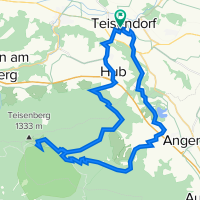
Cycling Route in Teisendorf, Bavaria, Germany

Teisenberg-Runde, Rund um die Stoißeralm

2
Open this route in the Bikemap app

Open this route in the Bikemap app

Open this route in Bikemap Web

Open this route in Bikemap Web

34 km
Distance
950 m
Ascent
953 m
Descent
-:-- h
Duration
-- km/h
Avg. Speed
--- m
Max. Elevation

About This Route

In den Ortsbereichen geteert, sonst fast ausnahmslos sehr gut gekiest. Nur die kurze Abfahrt von Neukirchen nach Oberteisendorf (zwischen Solarpark und Thumberg) ist für Nicht-MTB mit Vorsicht zu fahren. Bei der Poschennock-Dhtt. und beim Unterstand Hubertus gibt's Wasser (unkontrollierte Qualität).

This cycling route is ideal for: MTB

You will cycle on the following surfaces: Paved Gravel

Highlights Along The Route

Point of Interest

Sackgassen-Schild !! Nicht beachten, Straße durchgehend gekiest.

Point of Interest

Poschennock Diensthütte

Point of Interest

Unterstand Hubertushütte

More highlights are available with Bikemap for iOS and Android.

Customize this cycling route with the Bikemap route planner.

Make it yours!

Did you know? You can use this route as a template in our cycling route planner if you don't wish to start from scratch. Customize it based on your needs to plan your perfect cycling tour.

Open it in the app