Premium Badge Download on the App Store Get it on Google Play Turn-by-turn Navigation Offline Maps Bike Type Optimized Routing Premium Maps Custom Bike Computer Export Routes Route Previews Fall Detection Premium Support

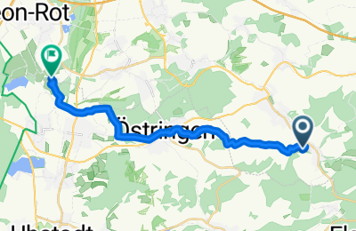
Cycling Route in Östringen, Baden-Württemberg, Germany

SAP Rot nach Waldangelloch (1)

0
Open this route in the Bikemap app

Open this route in the Bikemap app

Open this route in Bikemap Web

Open this route in Bikemap Web

15 km
Distance
132 m
Ascent
237 m
Descent
-:-- h
Duration
-- km/h
Avg. Speed
--- m
Max. Elevation

About This Route

Interessante Strecke, relativ direkter Weg. Weitgehend auf Fahrradwegen. Zwischen Östringen und Waldangelloch auf Feldwegen, die teilweise nicht asphaltiert sind. In diesem Bereich ist die Strecke auch recht hügelig. Bei nassem Wetter weniger empfehlenswert da es hier auch sehr matschig werden kann.

You will cycle on the following surfaces: Paved Unpaved

Customize this cycling route with the Bikemap route planner.

Make it yours!

Did you know? You can use this route as a template in our cycling route planner if you don't wish to start from scratch. Customize it based on your needs to plan your perfect cycling tour.

Open it in the app