

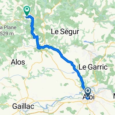
D-15. Albi - Adge (189,8 Km)
A cycling route starting in Albi, Occitanie, France.
Overview
About this route
- -:--
- Duration
- 189.8 km
- Distance
- 2,952 m
- Ascent
- 3,109 m
- Descent
- ---
- Avg. speed
- 977 m
- Max. altitude
Route quality
Waytypes & surfaces along the route
Waytypes
Road
19 km
(10 %)
Quiet road
19 km
(10 %)
Surfaces
Paved
55 km
(29 %)
Unpaved
5.7 km
(3 %)
Asphalt
55 km
(29 %)
Gravel
3.8 km
(2 %)
Route highlights
Points of interest along the route
Point of interest after 22.2 km
Côte de TELLET (3) Km 22,4 · 489 m
Point of interest after 42.7 km
Côte de GOUTIMALOUS (2) Km 43,4 · 718 m
Point of interest after 69.6 km
Col de la BASSINE (2) Km 70,6 · 896 m
Point of interest after 103 km
Col de COUSINES (3) Km 105,1 · 968 m
Point of interest after 103.8 km
Col des THÉRONDEIS (NP) Km 105,9 · 934 m
Point of interest after 122.5 km
Côte de GAVAUDAR (3) Km 124,9 · 539 m
Point of interest after 139.1 km
Col de FONTJUN (NP) Km 141,6 · 260 m
Point of interest after 165 km
Sprint BÉZIERS Km 186,5
Continue with Bikemap
Use, edit, or download this cycling route
You would like to ride D-15. Albi - Adge (189,8 Km) or customize it for your own trip? Here is what you can do with this Bikemap route:
Free features
- Save this route as favorite or in collections
- Copy & plan your own version of this route
- Split it into stages to create a multi-day tour
- Sync your route with Garmin or Wahoo
Premium features
Free trial for 3 days, or one-time payment. More about Bikemap Premium.
- Navigate this route on iOS & Android
- Export a GPX / KML file of this route
- Create your custom printout (try it for free)
- Download this route for offline navigation
Discover more Premium features.
Get Bikemap PremiumFrom our community
Other popular routes starting in Albi
 20150908_202842.gpx
- Distance
- 23.8 km
- Ascent
- 413 m
- Descent
- 82 m
- Location
- Albi, Occitanie, France
 2012 French Tour -- Ride Day 59 -- 25 October 2012 -- Albi -- Circle
- Distance
- 54.3 km
- Ascent
- 634 m
- Descent
- 633 m
- Location
- Albi, Occitanie, France
 2012 French Tour -- Ride Day 58 -- 23 October 2012 -- Albi -- Circle
- Distance
- 100.3 km
- Ascent
- 997 m
- Descent
- 999 m
- Location
- Albi, Occitanie, France
 Albi to Montauban
- Distance
- 75.4 km
- Ascent
- 968 m
- Descent
- 1,022 m
- Location
- Albi, Occitanie, France
 Rue de l'Ort en Salvy nach D9
- Distance
- 43.1 km
- Ascent
- 743 m
- Descent
- 777 m
- Location
- Albi, Occitanie, France
 2012 French Tour -- Ride Day 60 -- 28 October 2012 -- Albi to Blagnac (Toulouse)
- Distance
- 97 km
- Ascent
- 243 m
- Descent
- 268 m
- Location
- Albi, Occitanie, France
 2014 Ride Day 103 - Albi to Montauban
- Distance
- 74.1 km
- Ascent
- 387 m
- Descent
- 439 m
- Location
- Albi, Occitanie, France
 D-15. Albi - Adge (189,8 Km)
- Distance
- 189.8 km
- Ascent
- 2,952 m
- Descent
- 3,109 m
- Location
- Albi, Occitanie, France
Open it in the app