
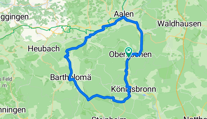
Bartholomä - Aalen
A cycling route starting in Oberkochen, Baden-Württemberg, Germany.
Overview
About this route
Oberkochen - Königsbronn - Zang - Bartholomä - Lauterburg - Essingen - Aalen - Unterkochen - Oberkochen
- -:--
- Duration
- 43.2 km
- Distance
- 469 m
- Ascent
- 471 m
- Descent
- ---
- Avg. speed
- 714 m
- Avg. speed
Route quality
Waytypes & surfaces along the route
Waytypes
Busy road
16.3 km
(38 %)
Road
15.4 km
(36 %)
Surfaces
Paved
41.3 km
(96 %)
Unpaved
0.7 km
(2 %)
Asphalt
41.2 km
(95 %)
Loose gravel
0.3 km
(<1 %)
Continue with Bikemap
Use, edit, or download this cycling route
You would like to ride Bartholomä - Aalen or customize it for your own trip? Here is what you can do with this Bikemap route:
Free features
- Save this route as favorite or in collections
- Copy & plan your own version of this route
- Sync your route with Garmin or Wahoo
Premium features
Free trial for 3 days, or one-time payment. More about Bikemap Premium.
- Navigate this route on iOS & Android
- Export a GPX / KML file of this route
- Create your custom printout (try it for free)
- Download this route for offline navigation
Discover more Premium features.
Get Bikemap PremiumFrom our community
Other popular routes starting in Oberkochen
 Bike the Rock - Heubach
- Distance
- 26.8 km
- Ascent
- 375 m
- Descent
- 527 m
- Location
- Oberkochen, Baden-Württemberg, Germany
 Härtsfeldrunde_3
- Distance
- 42 km
- Ascent
- 389 m
- Descent
- 385 m
- Location
- Oberkochen, Baden-Württemberg, Germany
 ETT 2016 10. Etappe Mittag
- Distance
- 87.6 km
- Ascent
- 349 m
- Descent
- 598 m
- Location
- Oberkochen, Baden-Württemberg, Germany
 Untere Rohrbachmuehle
- Distance
- 20.4 km
- Ascent
- 927 m
- Descent
- 425 m
- Location
- Oberkochen, Baden-Württemberg, Germany
 Mi-Radler 31052017
- Distance
- 36.7 km
- Ascent
- 329 m
- Descent
- 341 m
- Location
- Oberkochen, Baden-Württemberg, Germany
 Wolfratshausen
- Distance
- 164.9 km
- Ascent
- 1,016 m
- Descent
- 1,032 m
- Location
- Oberkochen, Baden-Württemberg, Germany
 AA--SHG--GP--RT
- Distance
- 121.9 km
- Ascent
- 422 m
- Descent
- 696 m
- Location
- Oberkochen, Baden-Württemberg, Germany
 albsteig aalen--donauwoerth
- Distance
- 105.6 km
- Ascent
- 976 m
- Descent
- 1,193 m
- Location
- Oberkochen, Baden-Württemberg, Germany
Open it in the app