
Beynat à vélo
Découvre une carte de 18 itinéraires et pistes cyclables près de Beynat, créés par notre communauté.
Portrait de région
Fais connaissance avec Beynat
Trouve l’itinéraire à vélo qui te convient à Beynat, où nous avons 18 pistes cyclables à explorer.
932 km
Distance enregistrée
18
Itinéraires cyclables
1 233
Population
Communauté
Utilisateurs les plus actifs à Beynat


De notre communauté
Les meilleurs itinéraires à vélo dans et autour de Beynat


Albussac (Les Quatre Routes) - Circle through Neuville
Itinéraire à vélo à Beynat, Nouvelle-Aquitaine, France
- 37,8 km
- Distance
- 686 m
- Montée
- 686 m
- Descente


Albussac (Les Quatre Routes) - Circle to Brive-la-Gaillarde (Malemort)
Itinéraire à vélo à Beynat, Nouvelle-Aquitaine, France
- 75,3 km
- Distance
- 1 422 m
- Montée
- 1 422 m
- Descente


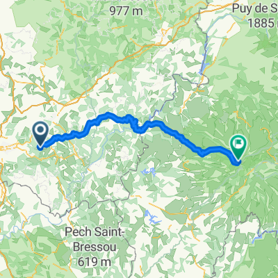
Albussac (Les Quatre Routes) to Égletons
Itinéraire à vélo à Beynat, Nouvelle-Aquitaine, France
- 53,5 km
- Distance
- 978 m
- Montée
- 889 m
- Descente


Albussac (Les Quatre Routes) - Circle through Tulle
Itinéraire à vélo à Beynat, Nouvelle-Aquitaine, France
- 59,4 km
- Distance
- 1 179 m
- Montée
- 1 180 m
- Descente
Découvrez plus d'itinéraires
 Albussac (Les Quatre Routes) - Circle to Argentat and Barrage
- Distance
- 63,9 km
- Montée
- 1 701 m
- Descente
- 1 696 m
- Emplacement
- Beynat, Nouvelle-Aquitaine, France
 Montée Lanteuil-Brousse
- Distance
- 7,7 km
- Montée
- 354 m
- Descente
- 95 m
- Emplacement
- Beynat, Nouvelle-Aquitaine, France
 Circuit championat
- Distance
- 9,7 km
- Montée
- 156 m
- Descente
- 156 m
- Emplacement
- Beynat, Nouvelle-Aquitaine, France
 puy mary 2
- Distance
- 116,8 km
- Montée
- 1 874 m
- Descente
- 824 m
- Emplacement
- Beynat, Nouvelle-Aquitaine, France
 Palazinges - Barrage aigle
- Distance
- 66,7 km
- Montée
- 508 m
- Descente
- 764 m
- Emplacement
- Beynat, Nouvelle-Aquitaine, France
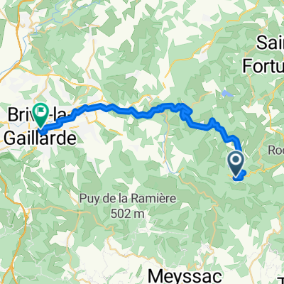 From Beynat to Brive-la-Gaillarde
- Distance
- 28,7 km
- Montée
- 485 m
- Descente
- 760 m
- Emplacement
- Beynat, Nouvelle-Aquitaine, France
 le planchat
- Distance
- 3,8 km
- Montée
- 212 m
- Descente
- 93 m
- Emplacement
- Beynat, Nouvelle-Aquitaine, France
 espagnagol
- Distance
- 7,1 km
- Montée
- 135 m
- Descente
- 135 m
- Emplacement
- Beynat, Nouvelle-Aquitaine, France