


Sherwood Rd, Sherwood to Parkwood Pl, Middle Park
Un itinéraire vélo au départ de Rocklea, State of Queensland, Australie.
Vue d'ensemble
À propos du circuit
0
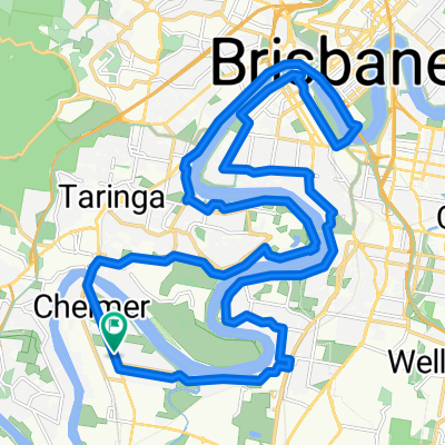
This route is mostly flat with only a small portion of climbing. It starts at the city centre and takes you past some residential areas and parks. After a few kilometres, you'll begin to ascend and reach your maximum elevation of six hundred seventy meters. This is a great opportunity to take in the views and enjoy the fresh air. After descending, you'll continue on your way back to the city centre. This route is a great choice for those looking for a moderate workout and a scenic ride.
Généré par l’IA
- 1:06 h
- Durée
- 13,8 km
- Distance
- 181 m
- Montée
- 167 m
- Descente
- 12,7 km/h
- Vit. moyenne
- 67 m
- Altitude max.
Alex
créé il y a 2 mois
Qualité de l’itinéraire
Types de voies et surfaces le long de l’itinéraire
Types de routes
Route tranquille
4,6 km
33 %
Piste cyclable
2,9 km
21 %
surfaces
Pavé
13,6 km
(98 %)
Asphalte
8 km
58 %
Pavé (non défini)
4,6 km
33 %
Continuer avec Bikemap
Utilise, modifie ou télécharge cet itinéraire vélo
Tu veux parcourir Sherwood Rd, Sherwood to Parkwood Pl, Middle Park ou l’adapter à ton propre voyage ? Voici ce que tu peux faire avec cet itinéraire Bikemap :
Fonctionnalités gratuites
- Enregistre cet itinéraire comme favori ou dans une collection
- Copie et planifie ta propre version de cet itinéraire
- Synchronise ton itinéraire avec Garmin ou Wahoo
Fonctionnalités Premium
Essai gratuit de 3 jours, ou paiement unique. En savoir plus sur Bikemap Premium.
- Navigue sur cet itinéraire sur iOS et Android
- Exporter un fichier GPX / KML de cet itinéraire
- Crée ton impression personnalisée (essaie-la gratuitement)
- Télécharge cet itinéraire pour la navigation hors ligne
Découvre plus de fonctionnalités Premium.
Obtiens Bikemap PremiumDe notre communauté
Rocklea : Autres itinéraires populaires qui commencent ici

 Primrose St, Sherwood to Primrose St, Sherwood0
- 34,8 km
- 299 m
- 301 m
- Rocklea, State of Queensland, Australie
 Sherwood Rd, Sherwood to Parkwood Pl, Middle Park0
- 13,8 km
- 181 m
- 167 m
- Rocklea, State of Queensland, Australie

 Primrose St, Sherwood to Primrose St, Sherwood0
- 31,6 km
- 266 m
- 267 m
- Rocklea, State of Queensland, Australie
 531 Oxley Rd, Sherwood to 539 Oxley Rd, Sherwood0
- 32,8 km
- 300 m
- 302 m
- Rocklea, State of Queensland, Australie
 494 Oxley Rd, Sherwood to 513 Oxley Rd, Sherwood0
- 20,1 km
- 159 m
- 159 m
- Rocklea, State of Queensland, Australie


Ouvre-la dans l’app