


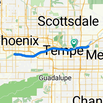
E Garfield St, Scottsdale to S Rural Rd, Tempe
Un itinéraire vélo au départ de Tempe, Arizona, États Unis.
Vue d'ensemble
À propos du circuit
0
You start at the intersection of Garfield and Ashford Streets in Scottsdale. This is a quiet street with a gentle incline. After a short time, you will reach the intersection of Ashford and Willow Road. This is a paved road, and you will continue for a short distance. After this, you will reach the intersection of Willow and Apache Road. This is a paved road, and you will continue for a short distance. After this, you will reach the intersection of Apache and Cactus Road. This is a paved road, and you will continue for a short distance. After this, you will reach the intersection of Cactus and Honey Road. This is a paved road, and you will continue for a short distance. After this, you will reach the intersection of Honey and Willow Road. This is a paved road, and you will continue for a short distance. After this, you will reach the intersection of Willow and Ashford Road. This is a paved road, and you will continue for a short distance. After this, you will reach the intersection of Ashford and Garfield Street. This is a paved road, and you will continue for a short distance. After this, you will reach the intersection of Garfield and Ashford Streets in Scottsdale.
Généré par l’IA
- 39 min
- Durée
- 11,1 km
- Distance
- 62 m
- Montée
- 75 m
- Descente
- 16,9 km/h
- Vit. moyenne
- 371 m
- Altitude max.
W Wilson
créé il y a 2 mois
Qualité de l’itinéraire
Types de voies et surfaces le long de l’itinéraire
Types de routes
Piste cyclable
8,2 km
74 %
Route tranquille
1,4 km
13 %
surfaces
Pavé
10,5 km
(95 %)
Non pavé
0,1 km
(1 %)
Béton
8,1 km
73 %
Asphalte
2,2 km
20 %
Continuer avec Bikemap
Utilise, modifie ou télécharge cet itinéraire vélo
Tu veux parcourir E Garfield St, Scottsdale to S Rural Rd, Tempe ou l’adapter à ton propre voyage ? Voici ce que tu peux faire avec cet itinéraire Bikemap :
Fonctionnalités gratuites
- Enregistre cet itinéraire comme favori ou dans une collection
- Copie et planifie ta propre version de cet itinéraire
- Synchronise ton itinéraire avec Garmin ou Wahoo
Fonctionnalités Premium
Essai gratuit de 3 jours, ou paiement unique. En savoir plus sur Bikemap Premium.
- Navigue sur cet itinéraire sur iOS et Android
- Exporter un fichier GPX / KML de cet itinéraire
- Crée ton impression personnalisée (essaie-la gratuitement)
- Télécharge cet itinéraire pour la navigation hors ligne
Découvre plus de fonctionnalités Premium.
Obtiens Bikemap PremiumDe notre communauté
Tempe : Autres itinéraires populaires qui commencent ici


 614–626 S McClintock Dr, Tempe to 1006 S McClintock Dr, Tempe1
- 59 km
- 201 m
- 197 m
- Tempe, Arizona, États Unis


Ouvre-la dans l’app