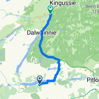
Kingussie - Aviemore
- 50,3 km
- 360 m
- 599 m
- Kingussie, Ecosse, Royaume-Uni
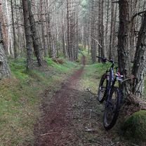
This is a relatively short route of 12km / 7.5 miles suitable for mountain bikes. Some sections are on tarmac but others are on rough paths and for one section the bike will need to be carried.<br /> Allow 2 hours.<br /> Ordinance Survey sheet 35 Kingussie and Monadliath Mountains.<br /> Refreshments: Cafes and bars in Kingussie and Newtonmore.<br /> <br /> Start in the centre of Kingussie by taking the Ardbroilach Road opposite the Star Hotel.<br /> Follow the road for about a mile following the waymarks for the Golf Course walk. When the waymarks turn left continue to follow this route and cross the Gynack over a bridge. The path at this point becomes steep with steps for a short section when the bike will have to be carried. Continue to follow the path and pass an abandoned cottage. Pass through a gate and enter woodland. The next section is a rough unsurfaced path but mostly navigable by mountain bike. <br /> As the path emerges out of the wood Loch Gynack now comes into view. Pass though another gate and follow the trail to the left uphill for a short incline. There is a junction here for the Kingussie paths network maintained by the Kingussie Community Development Company (KCDC).<br /> Follow the waymark to Newtonmore and from here the route leads through birchwoods alongside the loch. The surface is now much better.<br /> When the route emerges into the open again continue to follow the waymarks for Newtonmore and bear to the right onto a well-surfaced gravel track running alongside a plantation of pine. As the trees come to an end, pass through a gate and follow the waymark downhill to the left on a Land Rover track. When the track meets a tarmac road, turn left to go downhill and down to the Newtonmore Main Street.<br /> Turn left and on Main Street for 50 metres and pass the Highland Folk Museum. Just after the museum turn right to take the off-road cycle path back to Kingussie.<br /> <br /> Bikefast Scotland @ Kingussie

Bridge over Gynack burn

path with steps

Loch Gynack

Junction to Newtonmore

View to Creag Dhubh

KCDC waymark

Kingussie to Newtonmore cycle route
Essai gratuit de 3 jours, ou paiement unique. En savoir plus sur Bikemap Premium.
Découvre plus de fonctionnalités Premium.
Obtiens Bikemap PremiumOuvre-la dans l’app