Kingussie - Pitlochry
- 40,8 km
- 387 m
- 531 m
- Kingussie, Ecosse, Royaume-Uni
Un itinéraire vélo au départ de Kingussie, Ecosse, Royaume-Uni.
Vue d'ensemble
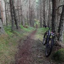
This route icludes a nice singletrack climb and 3 of the best descents in Inshriach. I've started the route in Drumguish. If you're biking from Kingussie add 3 miles each way and about 30 minutes. If you're taking a vehicle there is a small (unofficial) parking area about 100 yards up the Drumguish road on the left. Please make sure you don't block the driveway. From the parking area carry straight on through Drumguish on to a rough track and pass through a couple of gates into the forest. Carry straight on climbing gradually uphill on the forest road. After 1.9 miles (1) turn left on twintrack which soon becomes singletrack. After 700 yards take a sharp right turn uphill (2) next to a concrete water trough. Follow this nice singletrack climb to the end. At the forest road/track turn right and follow it round to the top of Creag Dhubh (trig point pillar) (3). RIDGELINE/STARWARS From the top carry on to a muddy path and take the left fork. The trail soon improves. After about 100 yards take the left hand trail. This soon emerges from the trees and winds its way across a clear felled area with good panoramic views. The trail arrives at a large solitary dead tree. From here follow the trail right and then left downhill and back into the forest. It now winds its way through the trees for some distance eventually emerging onto a more substantial trail. Go right and almost immediately left (4) onto another singletrack (Starwars). This is a fairly short section and features off camber tree routes. At the forest road turn left and at the end turn left again. At the next junction (5) take the left hand road and follow this uphill for 0.6 mile. Look out for a change in the road surface (becomes more overgrown). About 30 yards after the road surface changes keep an eye out for singletrack on the right (6)...easy to miss. THE TUNNEL Follow this track downhill...a few muddy and technical sections at first but fast and flowing lower down. At the forest road (7) turn left and after 600 yards look out for singletrack to right and left (8). Take the left one. Follow this for 1300 yards eventually arriving at the singletrack climb (9) that you did earlier. Follow this as before to the top of Creag Dhubh (10). THE GREEN DREAM From here carry on and this time take the right hand fork. After 200 yards the trail splits again (11). Take the left fork and follow it downhill with clear felled area to your left. Lots of roots and bumps to start with. Just after you enter the forest take the sharp right turn downhill. From here it is steep and fast all the way to the end. At the forest road turn right and follow this all the way eventually rejoining your outward route (1) back to Drumguish.
créé il y a 9 ans

Qualité de l’itinéraire
Route forestière
10,2 km
52 %
Sentier
8,4 km
43 %
Route tranquille
1 km
5 %
Non pavé
16,1 km
(82 %)
Gravier
8,4 km
43 %
Sol
7,7 km
39 %
Indéfini
3,5 km
18 %
Continuer avec Bikemap
Tu veux parcourir Inshriachs Best 3 Descents ou l’adapter à ton propre voyage ? Voici ce que tu peux faire avec cet itinéraire Bikemap :
Essai gratuit de 3 jours, ou paiement unique. En savoir plus sur Bikemap Premium.
Découvre plus de fonctionnalités Premium.
Obtiens Bikemap PremiumDe notre communauté
Ouvre-la dans l’app