
Jednodniowa wycieczka rowerowa z Barcelonnette do Saint-Martin-Vésubie
Dostosuj własną trasę na podstawie naszego szablonu lub zobacz, jak nasza społeczność najchętniej jeździ z Barcelonnette do Saint-Martin-Vésubie.
Szablon trasy
Z Barcelonnette do Saint-Martin-Vésubie
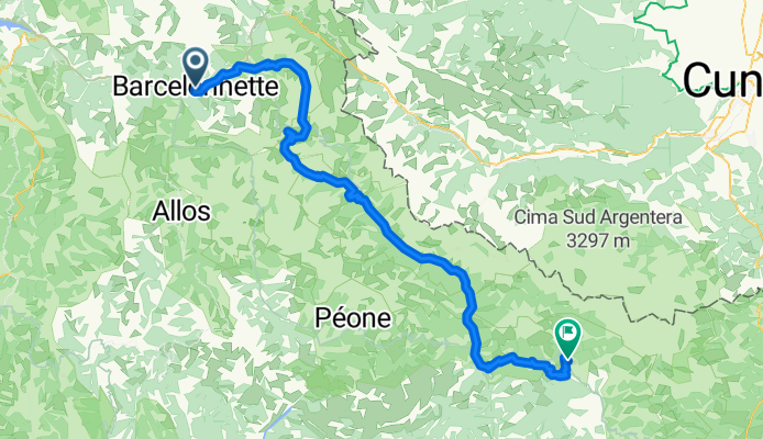
- 11 h 45 min
- Czas
- 114,4 km
- Dystans
- 6122 m
- Przewyższenia
- 6304 m
- Spadek
- 9,7 km/h
- Śr. Prędkość
- 2710 m
- Maks. wysokość
Get ready for a true Alpine adventure! This challenging route kicks off in Barcelonnette, a charming mountain town in the heart of the Ubaye Valley, known for its unique Mexican-influenced villas—thanks to townsfolk who struck it rich in Mexico and returned home. From here, you’ll head south, crossing several spectacular alpine passes, with a lung-busting total ascent of over 6,000 meters and breathtaking views all along.
Expect a real mix of surfaces: there’s plenty of gravel and unpaved tracks mingling with classic stretches of alpine asphalt, so a sturdy bike is a must. Along the way, you’ll ride through dramatic landscapes and tiny mountain hamlets, possibly catching a glimpse of marmots or eagles overhead.
Your ride ends in picturesque Saint-Martin-Vésubie, a characterful village nestled at the gateway to the Mercantour National Park. Grab a well-earned coffee at a local café and soak in the mountain air—you’ve just conquered a serious segment of the southern French Alps!
Wspólnota
Najlepsi użytkownicy w tym regionie


Od naszej społeczności
Najlepsze trasy rowerowe z Barcelonnette do Saint-Martin-Vésubie

Barcelonnette - Isola 2000 / Col de la Lombarde
Trasa rowerowa w Barcelonnette, Prowansja-Alpy-Lazurowe Wybrzeże, Francja
- 220,8 km
- Dystans
- 6059 m
- Przewyższenia
- 4861 m
- Spadek

RGA - ÉTAPE 6/7
Trasa rowerowa w Barcelonnette, Prowansja-Alpy-Lazurowe Wybrzeże, Francja
- 105,5 km
- Dystans
- 2238 m
- Przewyższenia
- 2877 m
- Spadek

Route des Grandes Alpes 2019 - stage 6
Trasa rowerowa w Barcelonnette, Prowansja-Alpy-Lazurowe Wybrzeże, Francja
- 123,8 km
- Dystans
- 3123 m
- Przewyższenia
- 2952 m
- Spadek

RdGA - Stage 6
Trasa rowerowa w Barcelonnette, Prowansja-Alpy-Lazurowe Wybrzeże, Francja
- 103 km
- Dystans
- 2279 m
- Przewyższenia
- 2903 m
- Spadek

RdGA Tag 7
Trasa rowerowa w Barcelonnette, Prowansja-Alpy-Lazurowe Wybrzeże, Francja
- 116,3 km
- Dystans
- 2629 m
- Przewyższenia
- 3032 m
- Spadek

Ruta Alpes 7
Trasa rowerowa w Barcelonnette, Prowansja-Alpy-Lazurowe Wybrzeże, Francja
- 104,1 km
- Dystans
- 2602 m
- Przewyższenia
- 2785 m
- Spadek

Route des Grandes Alpes Stage 6
Trasa rowerowa w Barcelonnette, Prowansja-Alpy-Lazurowe Wybrzeże, Francja
- 103 km
- Dystans
- 2266 m
- Przewyższenia
- 2886 m
- Spadek

Eté 2023 - Etapes 5 à 7
Trasa rowerowa w Barcelonnette, Prowansja-Alpy-Lazurowe Wybrzeże, Francja
- 102,3 km
- Dystans
- 3124 m
- Przewyższenia
- 3284 m
- Spadek

RDGA - Etape 5
Trasa rowerowa w Barcelonnette, Prowansja-Alpy-Lazurowe Wybrzeże, Francja
- 105,3 km
- Dystans
- 2266 m
- Przewyższenia
- 2908 m
- Spadek

07. Etappe "Route des Grandes Alpes"
Trasa rowerowa w Barcelonnette, Prowansja-Alpy-Lazurowe Wybrzeże, Francja
- 98 km
- Dystans
- 2157 m
- Przewyższenia
- 2296 m
- Spadek

Barcelonnette - Isola 2000
Trasa rowerowa w Barcelonnette, Prowansja-Alpy-Lazurowe Wybrzeże, Francja
- 188,9 km
- Dystans
- 4481 m
- Przewyższenia
- 3590 m
- Spadek

1. Barcelonette - Rubion
Trasa rowerowa w Barcelonnette, Prowansja-Alpy-Lazurowe Wybrzeże, Francja
- 95,2 km
- Dystans
- 2360 m
- Przewyższenia
- 2253 m
- Spadek
Odkryj więcej tras
 RdGA Tag 7
- Dystans
- 116,3 km
- Przewyższenia
- 2629 m
- Spadek
- 3032 m
- Lokalizacja
- Barcelonnette, Prowansja-Alpy-Lazurowe Wybrzeże, Francja
 Ruta Alpes 7
- Dystans
- 104,1 km
- Przewyższenia
- 2602 m
- Spadek
- 2785 m
- Lokalizacja
- Barcelonnette, Prowansja-Alpy-Lazurowe Wybrzeże, Francja
 Route des Grandes Alpes Stage 6
- Dystans
- 103 km
- Przewyższenia
- 2266 m
- Spadek
- 2886 m
- Lokalizacja
- Barcelonnette, Prowansja-Alpy-Lazurowe Wybrzeże, Francja
 Eté 2023 - Etapes 5 à 7
- Dystans
- 102,3 km
- Przewyższenia
- 3124 m
- Spadek
- 3284 m
- Lokalizacja
- Barcelonnette, Prowansja-Alpy-Lazurowe Wybrzeże, Francja
 RDGA - Etape 5
- Dystans
- 105,3 km
- Przewyższenia
- 2266 m
- Spadek
- 2908 m
- Lokalizacja
- Barcelonnette, Prowansja-Alpy-Lazurowe Wybrzeże, Francja
 07. Etappe "Route des Grandes Alpes"
- Dystans
- 98 km
- Przewyższenia
- 2157 m
- Spadek
- 2296 m
- Lokalizacja
- Barcelonnette, Prowansja-Alpy-Lazurowe Wybrzeże, Francja
 Barcelonnette - Isola 2000
- Dystans
- 188,9 km
- Przewyższenia
- 4481 m
- Spadek
- 3590 m
- Lokalizacja
- Barcelonnette, Prowansja-Alpy-Lazurowe Wybrzeże, Francja
 1. Barcelonette - Rubion
- Dystans
- 95,2 km
- Przewyższenia
- 2360 m
- Spadek
- 2253 m
- Lokalizacja
- Barcelonnette, Prowansja-Alpy-Lazurowe Wybrzeże, Francja
Trasy z Barcelonnette
Jednodniowa wycieczka rowerowa od
Z Barcelonnette do Castellane
Jednodniowa wycieczka rowerowa od
Z Barcelonnette do Puget-Théniers
Szybka przejażdżka rowerowa od
Z Barcelonnette do Jausiers
Trasy do Saint-Martin-Vésubie
Jednodniowa wycieczka rowerowa od
Z Puget-Théniers do Saint-Martin-Vésubie
Jednodniowa wycieczka rowerowa od
Z Jausiers do Saint-Martin-Vésubie