Premium Badge Download on the App Store Get it on Google Play Turn-by-turn Navigation Offline Maps Bike Type Optimized Routing Premium Maps Custom Bike Computer Export Routes Route Previews Fall Detection Premium Support

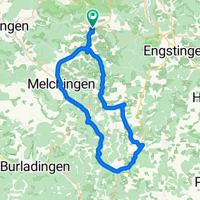
Cycling Route in Unterhausen, Baden-Württemberg, Germany

Am Albtrauf Reutlinger Alb mit Stoppomat

0
Open this route in the Bikemap app

Open this route in the Bikemap app

Open this route in Bikemap Web

Open this route in Bikemap Web

44 km
Distance
726 m
Ascent
747 m
Descent
-:-- h
Duration
-- km/h
Avg. Speed
839 m
Max. Elevation

About This Route

- Start/Ziel Lichtenstein-Unterhausen Parkplatz Sky-Supermarkt

- Auf der B312 ca.700m dann rechts abbiegen auf die Kalkofen-Steige (Stoppomat-Strecke)

- Weiter Richtung Nebelhöhle, dann nach Sonnenbühl-Genkingen

- Undingen, Willmandingen, Melchingen

- Am Ortseingang von Melchingen rechts nach Talheim

- Kurz vor Mössingen am Kreisverkehr rechts nach Öschingen, Gönningen und über Pfullingen wieder zurück nach Unterhausen

This cycling route is ideal for: Road bike

You will cycle on the following surfaces: Paved

Customize this cycling route with the Bikemap route planner.

Make it yours!

Did you know? You can use this route as a template in our cycling route planner if you don't wish to start from scratch. Customize it based on your needs to plan your perfect cycling tour.

Open it in the app